REFERENCES
Bond, T.A., 1972, A Lower Cretaceous (Aptian-Albian) palynological assemblage from the
DeQueen Formation, Pike County, Arkansas: Pollen et Spores, vol. 14, pp. 173-186.
Edelman, D.W. and J.B. Urban, 1974, Palynology of the Comanche Peak Limestone
(Albian) at Comanche Peak,
Hood County, Texas: S-C Geol. Sec. Amer., abstract, p. 101.
Fontaine, W.M., 1894, Notes on some fossil plants from the Trinity Division of the
Comanche Series of Texas: U.S. National Mus.Proc., (for the year 1893), vol. 16, no. 934
pp. 261-282.
Graves, J., 1960, Goodbye to a River: New York, Alfred A. Knopf, Inc., 306 p.
________, 1974, Hard Scrabble, Observations on a patch of land: New York, Alfred Knopf,
Inc. 267 p.
Hedlund, R.W. and G. Norris, 1968, Spores and pollen grains from Fredericksburgian
(Albian) strata, Marshall County, Oklahoma: Pollen et Spores, vol. 10, pp. 129-159.
Kessler, L.G., 1968, Palynology and paleobotany of the Glen Rose Formation, North and
Central Texas: Unpublished M.A. thesis, Univ. Texas, Austin, 168 p.
Nunn, W.C., 1975, Somervell, Story of a Texas County: Fort Worth, Texas Christian
University Press, 258 p.
Phillips, P.P. and C.J. Felix, 1971a, A study of Lower and Middle Cretaceous spores and
pollen from the Southeastern United States. I Spores: Pollen et Spores, vol. 13, no. 2,
pp. 279-348.
____________________, 1971b, A study of Lower and Middle Cretaceous spores and pollen from
the Southeastern United States. II Pollen: Pollen et Spores, vol. 13, no. 3, pp. 447-473.
Srivastava, S.K., 1975, Microspores from the Fredericksburg Group (Albian) of the Southern
United States: Paleobiologie Continentale, vol. VI, no. 2, pp. 1-119.
Wingate, F.H., 1974, Palynology of the Denton Shale (Lower Cretaceous of Southeastern
Oklahoma: Unpublished Ph.D. dissertation, Univ. of Oklahoma, 265 p.
7
8
ALTERNATING MARINE AND TERRESTRIAL ENVIRONMENTS IN THE
COMANCHE CRETACEOUS LOWER GLEN ROSE FORMATION,
SOMERVELL AND HOOD COUNTIES, TEXAS
Bob F. Perkins
Introduction. Alternating beds of the Comanche Cretaceous Glen Rose Formation are
excellently exposed in the Paluxy River valley of North-Central Texas and record a
sedimentary history of shifting depositional environments along the margin of a shallow
sea. Analysis of abundant associated land and marsh plants, dinosaur tracks, shore-zone
and subtidal invertebrates, and shallow marine to terrestrial lithic and depositional
features in these beds has resulted in reconstruction of a complex local geologic history.
The purpose of this field trip will be to examine some of the paleontologic and
sedimentary features that characterize the principal sedimentary cycles of the Glen Rose
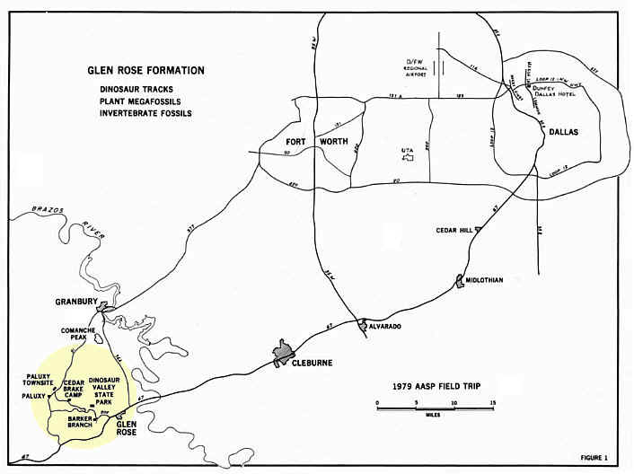
Formation in the valley of the Paluxy River in Somervell and Hood counties, North-Central
Texas (Fig. 4). Exposures at four localities will be examined beginning about two miles
west of Glen Rose and progressing westward, updip and landward at about three mile
intervals to the town of Paluxy about ten miles west of Glen Rose (Fig. 5). The first,
third, and fourth localities (Barker Branch, Cedar Brake Camp, and Paluxy Townsite) are
described in this article, and the second locality (Dinosaur Valley State Park) is the
subject of a separate paper by Wann Langston, Jr. in this guidebook.
Geological Setting. Comanchean rocks in this area were deposited on the
northeastern part of the Central Texas Platform north of the Llano Uplift (Fig. 4), which
was exposed as a large island of pre-Mesozoic rocks at the beginning of Cretaceous time.
The Luling-Mexia-Talco or Balcones Fault Zone is the approximate eastern boundary of the
Central Texas Platform and divides it from the East Texas Embayment or Basin.
9
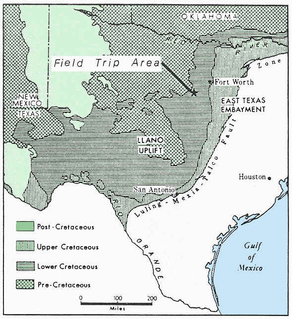
Figure 4. Generalized geologic map of a portion of Texas
showing location of field trip area.
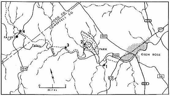
Figure 5. Index map of the Paluxy River valley showing
locations of field trip stops. 1, Barker Branch; 2, Dinosaur Valley State Park; 3,
Cedar Brake Camp; 4, Paluxy Townsite.
10
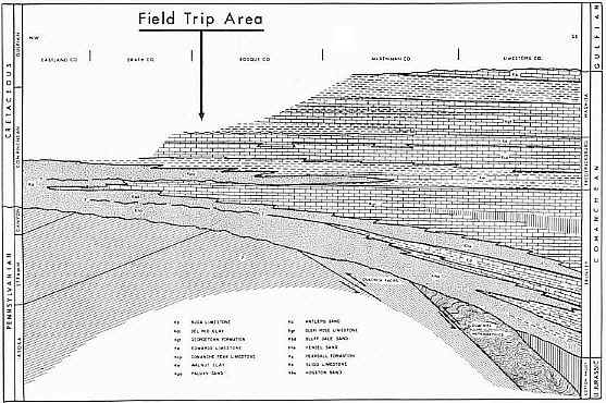
Figure 6. Diagram showing regional stratigraphic relationships
of Comanchean formations in Central Texas. Dip section drawn along a
northwest-southeast line passing about 15 miles southwest of the field trip area.
From Hayward and Brown (1967, Fig. 1).
11
Comanchean formations lie unconformably upon westward dipping
Pennsylvanian rocks in this area (Fig. 6). The erosional surface upon which the initial
Comanchean sediments rest dips southeastward at about 15 feet per mile and is of low
relief (Boone, 1968, p. 13). This surface was named the Wichita paleoplain by Hill (1901,
p. 363), who first recognized its erosional origin.
In the field trip area the Comanchean strata strike N 100 E and dip southeastward at ten
to 15 feet per mile. They thicken gradually southeastward across the shelf area but
thicken rapidly beyond the fault zone downdip into the East Texas Basin.
Glen Rose Formation - Stratigraphy. Throughout Central Texas the Glen Rose outcrop
belt is characterized by a stairstepped topography developed on the alternating resistant
and weak beds of the formation. In his early work on the Texas Cretaceous R. T. Hill used
the descriptive term "Alternating Beds" for this sequence of uniformly bedded,
arenaceous, argillaceous, and chalky limestones. In 1891 (p. 504, 507) he applied the name
Glen Rose Formation to exposures of the formation in bluffs along the Paluxy River near
the town of Glen Rose, Somerveil County.
The Glen Rose Formation and Bluff Dale Sand comprise the Trinity Division in the Paluxy
River valley. The Trinity Division is the basal unit of three tectonic-sedimentary
lithogenetic entities that make up the Comanche Series in Central Texas (Fig. 6). Each
Comanchean division is composed of one or more elastic-carbonate couplets recording a
transgressive episode in Comanchean history (Lozo and Stricklin, 1956). In the field trip
area the Glen Rose Formation is the carbonate phase of the elasticcarbonate couplet that
began with the underlying Bluff
12
Dale Sand. In the type area near Glen Rose the Glen Rose Formation is
approximately 240 feet thick (Rodgers, 1967), but it thins rapidly westward and is only
150 feet thick at Paluxy Townsite about ten miles west of Glen Rose (Fig. 7). The thinning
of the Glen Rose to the west is the result of replacement of limestone by sand, and
therefore the upper Bluff Dale beds at Paluxy Townsite are the time equivalent of the
basal Glen Rose beds along the Paluxy River near Glen Rose (Rodgers, 1967; Hayward and
Brown, 1967)
The stratigraphy of the Glen Rose in the type area has been studied by several workers
since Hill's initial investigations. The most important of these studies is that of
Rodgers (1967) who examined the stratigraphy of the type area in both detailed outcrop and
subsurface sections. He established correlations within the formation along the Paluxy
River and determined the updip relationship of the basal Glen Rose beds to the Bluff Dale
Sand. Rodgers' subdivision of the Glen Rose Formation into three units is followed in this
guidebook (Fig. 7). The lower Glen Rose Formation or Unit I of Rodgers is the principal
focus of this field trip.
Glen Rose Formation - Paleontology (Plates 1-6). Several invertebrate fossils from
the Glen Rose of this area were described by Hill in 1893 and were used by him to confirm
the "lowest Cretaceous" age for the Trinity Division. He incorrectly correlated
the Trinity with the Neocomian of Europe; but he was basing the age determination on a
bivalve and Orbitolina fauna and had not yet discovered diagnostic Trinity
ammonites or other types of fossils essential for intercontinental correlations in the
Cretaceous. Later work by Scott (1940) and Young (1974) established that the Glen Rose
ammonite faunas in Central Texas represent the uppermost Aptian and Lower Albian of the
standard European section.
13
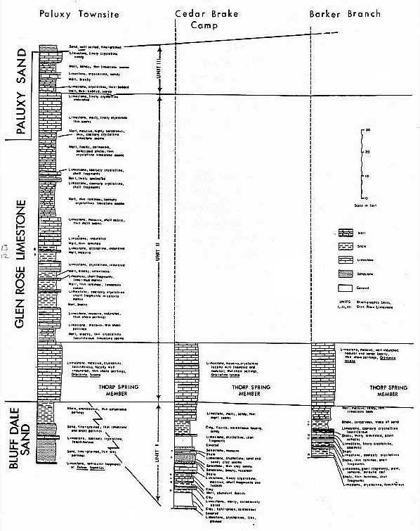
Click here for enlargement of graph.
Figure 7. Graphic sections and correlations of formations
exposed at Paluxy Townsite, Cedar Brake Camp, and Barker Branch localities. Adapted
from Rodgers (1967, Fig. 6).
14
Plant fossils in the Glen Rose of this area were noted first by Hill
(1893, p. 17-18). Fontaine (1894) described a megafossil flora of 23 species and varieties
from a locality near Glen Rose (probably the Barker Branch locality of this guidebook) and
compared the flora to that of the Lower Cretaceous Potomac beds in Virginia (see Pls. More
recently, L. G. Kessler (1968) has examined the Glen Rose megafossil and microfossil flora
in the type area and has attempted to interpret their paleoecologic significance.
Megafossil floras in other marginal marine or terrestrial Cretaceous deposits of Central
and North Texas have been described, and comparisons among them are important in
interpreting the paleoecology and depositional environments of the plant-bearing and
related strata. Wieland (1931) described five species of cycadeoids from the "Trinity
beds" (probably Paluxy Sand) of Central and North Texas. Ball (1937) described three
species of dicotyledons from concretions in the Paluxy Sand northwest of Stephenville,
Erath County. In the Gulfian Cretaceous Woodbine Sand of North Texas deposits similar to
the near-shore and terrestrial facies of the Glen Rose, Bluff Dale, and Paluxy formations
have yielded 82 species of plant megafossils including a fungus, ferns, cycads, conifers,
and 73 species of dicots (Berry, 1922; MacNeal, 1958).
Glen Rose Formation - Depositional History. The lower Glen Rose Formation (Unit I,
Fig. 7) along the Paluxy River is highly variable Lithologically and includes lime
mudstone, lime grainstone, argillaceous lime grainstone, lime packstone and wackestone,
mudstone, and quartz sandstone layers. Individual beds are relatively uniform in thickness
but change aspect laterally very rapidly. Correlation of sections can be made with
reference to a stratigraphic datum such as the base of the Thorp Spring Member (Fig. 7),
but correlation of individual beds is not normally feasible over distances greater than
one or two miles.
15
Planar cross-bedding, channel cut-and fill, bioturbation, bored and
encrusted cobbles, halite crystal casts, shape- and size-sorted shell layers,
stromatolites, and other primary sedimentary features are well preserved in Unit I.
Fossils include plant microfossils, miliolids, ostracods, mud-burrowing clams and snails,
marsh mussels, oysters, serpulid worm tubes, marsh and land plant stems, roots and cones,
and ichnofossils such as clam and snail burrows and trails, crustacean burrows, and
dinosaur tracks.
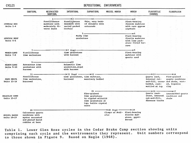
Nagle (1968) examined the lower Glen Rose Formation (Unit I) in exceptional detail at
Localities along the Paluxy River from Glen Rose to Paluxy Townsite, including localities
visited on this field trip. He analyzed the biologic and sedimentologic features and
related them to the stratigraphic sequence and their geographic distribution int order to
reconstruct the geologic history of events along the edge of the advancing Glen Rose sea.
He was able to recognize a series of seven primarily regressional cycles in Unit I. Each
cycle records an over-all subtidal to supratidal sequence but differs from the other
cycles in details of lithology and paleontology.
The beginning of each cycle is marked by subtidal or intertidal sediments resting on
supratidal or subterrestrial sediments. Crustacean burrows usually penetrate the upper
member of the underlying cycle. The intertidal phase of the cycle is marked by tidal flat
and beach deposits. Intertidal sediments are well-sorted, and stromatolitic laminae are
common. The supratidal phase is made up of fissile marsh shales rich in root mottling and
organic material or of mixed sandstones. Halite crystal casts, celestite and gypsum are
common, and plants or plant fragments are abundant. The terrestrial phase is marked by the
intrusion of flood-plain elastic wedges that thicken updip and are made up of yellowish
sand and clay
with abundant lignite.
16
Nagle recognized seven cycles in Unit I, and all of them are
completely or partially developed at the Cedar Brake Camp locality. Nagle's measured
section at Cedar Brake Camp is reproduced in Figure 9, and the seven cycles and their
identifying characteristics are summarized in Table 1.
FIELD TRIP LOCALITIES
Field trip stops at Barker Branch, Cedar Brake Camp, and Paluxy
Townsite will be concerned chiefly with examination of plant and invertebrate fossils,
ichnofossils, lithologies, sedimentary features and depositional sequences characterizing
lower Glen Rose depositional cycles and with reconstruction of the cyclical regress
ive-transgressive depositional pattern of the marginal-marine Glen Rose deposits.
The observations, interpretations, and conclusions summarized here and presented in the
field are based upon carefully detailed stratigraphic studies of Rodgers (1967), the
paleobotanical and palynological work of Kessler (1968), the analytical study of Glen Rose
cycles by Nagle (1968), and the results of many discussions and field studies with
graduate students at Louisiana State University over a period of several years.
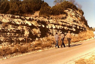
Barker Branch (Figure 8). Barker Branch is a northward flowing tributary of the
Paluxy River entering the river about 2.2 miles west of Glen Rose, Somervell County,
Texas. The illustrated section was measured in the stream cut at the first low-water
crossing of the Paluxy River downstream from Barker Branch, in the river bed upstream from
the crossing and in the bluffs on the east and west sides of Barker Branch at its mouth.
The section combines data from Rodgers (1967), Kessler (1968), Nagle (1968), and the
writer's unpublished field records.
17
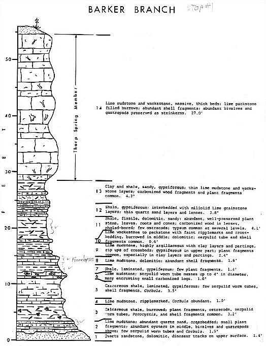
Click here for enlargement of graph.
Figure 8. Graphic section of the lower Glen Rose Formation and
the Thorp Spring Member exposed at Barker Branch. Based on unpublished field notes
with additional data from Kessler (1968) and Rodgers (1967).
18
This locality is probably the site from which J. W. Harvey collected
the plant material that was described by Fontaine (1894). Fontaine's illustrations are
reproduced in this guidebook in Plates 1-4.
The principle features to be examined here include:
1. Dinosaur tracks in the river bed.
2. Serpulid "patch reefs" up to three or four feet
in diameter in the river bed at the mouth of
Barker Branch.
3. Corbula bed made up of articulated detrital
Corbula shells in the stream cut.
4. Remnants of a beach deposit with southeastward
dipping crossbeds, ripples, and crossbed rip-ups
at the base of the bluff on the southwest side
of the stream junction.
5. Marsh deposits with abundant plant fossils in the
lower part of the bluff northwest of the beach
deposits.
Cedar Brake Camp (Figure 9). Cedar Brake Camp locality is a
prominent bluff 4.4 miles southeast of Paluxy Townsite on the north side of the Glen
Rose-Paluxy county road running along the north side of the Paluxy River. The correlation
of this section with Barker Branch and Paluxy Townsite localities is given in Figure 7. A
detailed graphic section by Nagle (1968, p. 5) is given in Figure 9 and illustrates the
features to be seen here. Table 1 serves as a guide to identification of the cycles and
their interpretation as exposed at this locality.
Paluxy Townsite (Figures 7 and 10). The Paluxy Townsite locality includes exposures
in an abandoned sand pit northwest of the intersection of the Glen Rose-Paluxy county road
and Ranch Road 204 northwest of the present town of PaLuxy, in the low bluff west of the
19
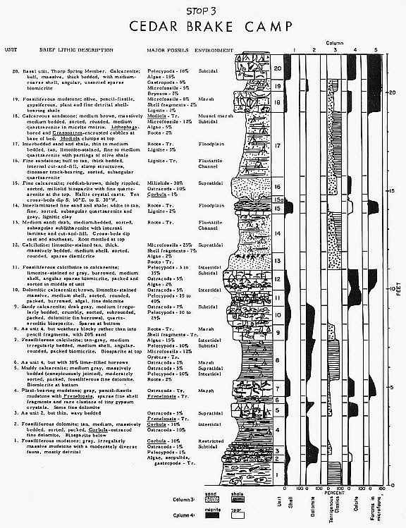
Click here for enlargement of image.
Figure 9. Graphic section of the lower Glen Rose Formation and
the basal part of the Thorp Spring Member exposed at Cedar Brake Camp. From Nagle
(1968, Fig. 2).
20
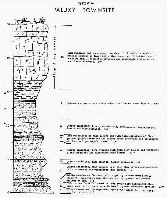
Figure 10. Graphic section of the Bluff Dale Sand and lower
part of Thorp Spring Member of the Glen Rose Formation exposed at Paluxy Townsite.
See Fig. 7 for remainder of Glen Rose Formation exposed at this locality.
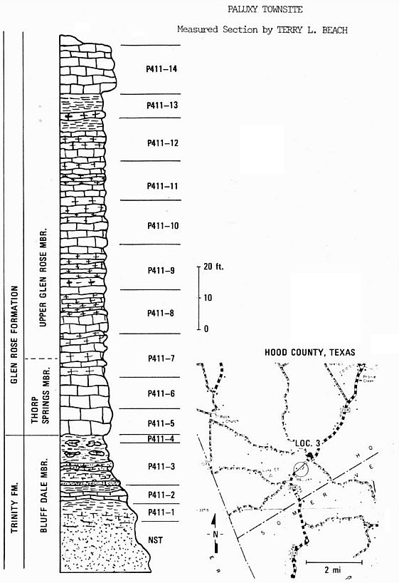
Measured section by Terry L. Beach (complete section).
21
pit, and in the roadcut and slope above on Ranch Road 204 northeast
of the sand pit, Hood County, Texas. The upper 25 feet of the Bluff Dale Sand is exposed
in the sand pit and in the lower part of the bluff west of the pit; the lower eight to ten
feet of the Thorp Spring Member of the Glen Rose caps the bluff; and a complete Upper Glen
Rose section of about 150 feet and the basal ten feet of the overlying Paluxy Sand are
exposed in the roadcut and hill slope above on Ranch Road 204 northeast of the pit.
The principle features to be examined here are in the Bluff Dale Sand and basal Thorp
Spring Member and include:
1. Crassostrea franklini camelina zone with
assoclated oyster and worm tube
encrusted bored pebbles in the lower part of the exposed Bluff
Dale and
representing the updip and landward extension of the oyster zone
in the
mussel-marsh cycle at Cedar Brake Camp (Bed 18, Fig. 9).
2. Bluff Dale Sand representing the updip floodplain and marsh cycle.
3. The basal subtidal beds of the Thorp Spring Member with its diverse, normal
marine assemblage.
For comparison with the lower Glen Rose cycles the following can also
be seen here in the roadcut and hill east of the sand pit:
1. Middle Glen Rose beds (Unit II) with a diverse fauna representing
the
maximum extent of the Trinity marine transgression in Central
Texas.
2. Upper Glen Rose beds (Unit III) with a restricted marine and brackish water
fauna, carbonized wood, lime grainstones, and other features
indicating the
onset of the regressive phase of Trinity depositional history.
22
REFERENCES
Ball, O.M., 1937, A dicotyledonous florule from the Trinity Group of
Texas: Jour. Geol., vol. 45, pp. 528-537, 8 figs.
Berry, E.W., 1922, The flora of the Woodbine Sand at Arthurs Bluff, Texas: U.S. Geol.
Survey, Prof. Pap. 129, pp. 153-181, 1 fig., 5 pls.
Boone, P.A., 1968, Stratigraphy of the basal Trinity sands (Lower Cretaceous) of Central
Texas: Baylor Geol. Studies Bull. 15, 64 p., illus.
Fontaine, W.M., 1894, Notes on some fossil plants from the Trinity division of the
Comanche Series of Texas: Proc. U.S. Nat. Museum, vol. 16 (1893), pp. 261-282, 8 pls.
Hayward, O.T. and Brown, L.F., Jr., 1967, Comanchean (Cretaceous) rocks of Central Texas:
in Comanchean (Lower Cretaceous) stratigraphy and paleontology of Texas: Sec. Econ.
Paleontologists and Mineralogists, Permian Basin Sec., Pub. 67-8, pp. 31-48.
Hill, R.T., 1891, The Comanche Series of the Texas-Arkansas region: Bull. Geol. Sec.
America, vol. 2, pp. 503-528.
__________, 1893, Paleontology of the Cretaceous formations of Texas; the invertebrate
paleontology of the Trinity division: Proc. Biol. Sec. Washington, vol. 8, pp.9-40, 8 pls.
__________, 1901, Geography and geology of the Black and Grand Prairies, Texas, with
detailed descriptions of the Cretaceous formations with special references to artesian
water: U.S. GeoL. Survey, 21st Ann. Rept., pt. 7, 666 p., 80 figs., 71 pls.
Kessler, L.G., II, 1968, Palynology and paleobotany of the Glen Rose Formation, North and
Central Texas: Unpub. Master's Thesis, U. Tex., Austin, 168 p.
Lozo, F.E. and Stricklin, F.L., 1956, Stratigraphic notes on the outcrop basal Cretaceous,
Central Texas: Trans. Gulf Coast Assoc. Geol. Societies, vol. 6, pp. 67-78, 8 figs.
MacNeal, D.L., 1958, The flora of the Upper Cretaceous Woodbine Sand in Denton County,
Texas: Acad. Nat. Sci. Philadelphia, Monograph 10, 152 p., 36 pls.
Nagle, J.S., 1968, Glen Rose cycles and facies, Paluxy River Valley, Somervell County,
Texas: U. Tex. Austin, Bur. Econ. Geol., Geol. Circ. 68-1, 25 p., 7 figs.
Rodgers, R.W., 1967, Stratigraphy of Glen Rose Limestone, Central
Texas: in Comanchean (Lower Cretaceous) stratigraphy and paleontology of Texas: Sec. Econ.
Paleontologists and MineraLogists, Permian Basin Sec., Pub. 67-8, pp. 119-130.
Scott, Gayle, 1940, Cephalopods from the Cretaceous Trinity Group of the South-Central
United States: Univ. Texas, Bull. 3945, pp. 969-1125, figs. 138-179, pls. 55-68.
Wieland, G.R., 1931 Land types of the Trinity beds: Science, vo1.;4 pp. 393-395.
Young, K.P., 1974, Lower Albian and Aptian (Cretaceous) ammonites of Texas: Geoscience and
Man, vol. 8, pp. 175-228, 31 figs., 16 pls.
23-24
25
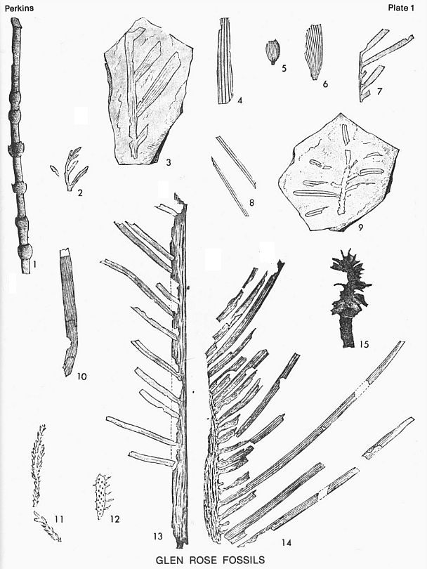
PLATE 1
All illustrations from Fontaine (1894). All figures apparently
natural size unless indicated otherwise. Plate and figure numbers in -parentheses refer to
Fontaine's illustrations.
| Fig. 1 |
Equisetum texense Fontaine, 1894. Stem showing tumid
sheaths. (Pl. 36, fig. 1) |
| Fig. 2 |
Sphenopteris valdensis Heer.? Terminal portion of an
ultimate pinna. (Pl. 36, fig. 2) |
| Fig. 3 |
Dioonites buchianus, var. rarinervis Fontaine,
1894. Portion of a leaf of medium size showing insertions of the leaflets. (Pl. 36, fig.
3) |
| Fig. 4 |
Dioonites buchianus, var. rarinervis Fontaine,
1894. Terminal portion of a large leaflet showing veins. (Pl. 36, fig. 4) |
| Fig. 5 |
Podozamites acutifolius Fontaine ? Basal portion of
small leaflet narrowing to a pedicel at base. (Pl. 36, fig. 7) |
| Fig. 6 |
Podozamites sp.? BasaL portion of a leaflet. (Pl. 36, fig. 8) |
| Fig. 7 |
Dioonites buchianus, var. angustifolius
Fontaine. Leaflets showing their narrow form. (Pl. 36, fig. 6) |
| Fig. 8 |
Pinus sp.? Short bits of two leaves that are narrow, rigid and
with one vein. (Pl. 36, fig. 11) |
| Fig. 9 |
Abieites linkii (Roemer) Dunk. End of an ultimate twig
with several leaves attached. (Pl. 37, fig. 2) |
| Fig. 10 |
Dioonites buchianus Schimper. Leaf showing fine,
closely-placed veins. (Pl. 36, fig. 5) |
| Fig. 11 |
Sphenolepidium sternbergianum, var. densifolium
Fontaine. Plant showing closely crowded, narrow acicular, incurved leaves. (Pl. 36, fig.
10) |
| Fig. 12 |
Laricopsis longifolia Fontaine. Imprint of small
cylindrical stem with attached bases of several very narrow leaves and with small
depressions that
appear to be scars of fallen leaves or leaf bundles. (Pl. 36, fig. 9) |
| Fig. 13 |
Dioonites dunkerianus (Gopp.) Miquel. Large leaf with
entire width of the midrib preserved. (Pl. 36, fig. 12) |
| Fig. 14 |
Dioonites dunkerianus (Gopp.) Miquel. A portion of a
large leaf with leaflets of only one side preserved. (Pl. 37, fig. 1) |
| Fig. 15 |
Abietites sp.? Fragmentary cone. (Pl. 43, fig. 4) |
26
27
28
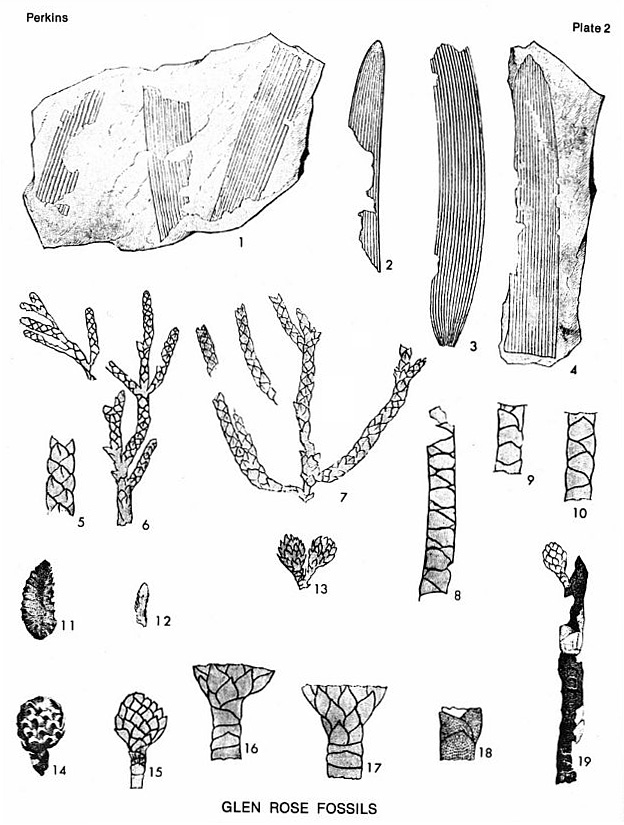
PLATE 2
All illustrations from Fontaine (1894). All figures apparently
natural size unless indicated otherwise. Plate and figure numbers in parentheses refer to
Fontaine's illustrations.
Figs. 1-4 Zamites tenuinervis Fontaine. |
|
1. Portions of three leaflets that were apparently attached to the
same stem. (Pl. 38, fig. 1)
2. End of leaflet. (Pl. 37, fig. 3)3. Leaflet showing curving shape of some
of the forms. (Pl. 37, fig. 4)
4. A portion of one of the broadest leaflets. (Pl. 38, fig. 2)
|
| Figs. 5-7, 11, 12 Brachyphyllum texense Fontaine, 1894. |
|
5. Enlargement of a portion of the branch in fig. 6 showing leaves with subacute,
lancet-shaped tips and with strong keels. (Pl. 39, fig. 1A)
6. End of compound branch with closely imbricated, leathery, thick, scale-like leaves,
which had a dense, durable epidermis. (Pl. 39, fig. 1)
7. Portion of large branch showing twigs diverging widely from stems before
curving upwards and showing dichotomous division of
branches. (Pl. 38, fig. 5)
11. Probable cone. (Pl. 38, fig. 3)12. Small staminate ament. (Pl. 38, fig.
4)
|
| Figs. 8-10, 13-19 Pagiophyllum dubium Fontaine, 1894. |
|
8-10. Twigs showing how very large the leaves are in proportion to the diameter
of the twigs. (Pl. 39, fig. 2-4)
13. Pair of cones at the tip of a twig. (Pl. 39, fig.5)
14. Cone with scales preserved but beak-like projections lost. (Pl. 39, fig. 6)
15. Cone of large size showing imprint with scales removed and showing abbreviated leaves
at tip of the twig that bears it. (Pl. 39, fig. 7)
16,17 Magnified portions of cone-bearing twigs with abbreviated leaves. (Pl. 39, figs. 8,
9)
18. Several leaves considerably magnified to show lines of stomata. (Pl. 39, fig. 10)
19. Twig with attached cone-bearing twig. (Pl. 39, fig. 11) |
29
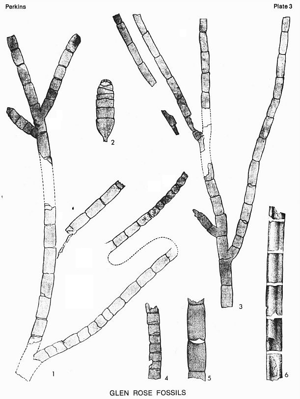
PLATE 3
All illustrations from Fontaine (1894). All figures apparently
natural size unless indicated otherwise. Plate and figure numbers in parentheses refer to
Fontaine's illustrations.
| Figs. 1-6 Frenelopsis varians Fontaine,
1894. |
|
1. Twig with irregular joint lengths. (Pl. 40, fig. 1)
2. Undeveloped short ultimate twig times two. (Pl. 40, fig. 2)
3. More common regularly jointed twig showing very slightly developed teeth or leaves with
very broad, low triangular form. (Pl. 41, fig. 3)
4. Twig showing a uniformly jointed form. (Pl. 41, fig. 2)
5. Magnification of part of fig. 3 showing leaves. (Pl. 41, fig. 3A)
6. Largest twig seen, a fragment. (Pl. 41, fig; 1) |
30
31
32
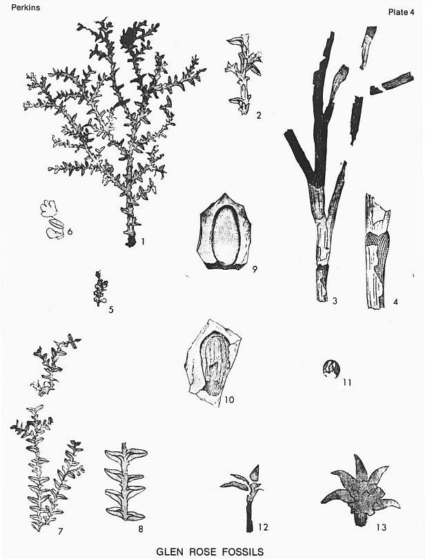
PLATE 4
All illustrations from Fontaine (1894). All figures apparently natural size unless
indicated otherwise. Plate and figure numbers in parentheses refer to Fontaine's
illustrations.
Figs. 1,2,5-8 Sequoia pagiophylloides
Fontaine, 1894. |
|
1. A nearly complete branch. (Pl. 42, fig. 1) 2.
Magnified portion of the main stem of specimen in fig. 1 showing facial leaves. (Pl. 42,
fig. 1A)
5. Group of aments of natural size. (Pl. 42, fig. 3)
6. A portion of specimen in fig. 5 enlarged to show a normal lateral leaf. (Pl. 42, fig.
3A)
7. Specimen with lateral leaves of the largest size but no facial leaves. (Pl. 42, fig. 2)
8. A portion of the specimen in fig. 7 enlarged to show the character of the lateral
leaves. (Pl. 42, fig. 2A)
|
| Figs. 3,4 Frenelopsis hohenggeri (Ett.) Schenk. |
|
3. Stem showing joints bearing distinctly developed short triangular leaves in
whorls of three. (Pl. 42, fig. 4)
4. Portion of stem in fig. 3 enlarged to show character of leaves. (Pl. 42, fig. 4A)
|
| Fig. 9 Carpolithes harveyi Fontaine, 1894. Form of a
seed with a large amount of woody tissue and smooth surface preserved in lignite. (Pl. 43,
fig. 3) |
| Fig. 10 Carpolithes obovatus Fontaine, 1894. Macerated
seed. (Pl. 43, fig. 5) |
| Fig. 11 Cycadeospermum rotundatum Fontaine. Spherical
seed with durable, brown enamel-like epidermis. (Pl. 43, fig. 6) |
| Fig. 12,13 Williamsonia texana Fontaine, 1894. |
|
12. Small stem showing some of the leaves at the end. (Pl. 43, fig. 1)
13. Specimen with a portion of both whorls somewhat contorted and with stem only partially
shown. (Pl. 43, fig. 2) |
33
PLATE 5
All figures natural size unless indicated otherwise.
| Fig. 1 |
Frenelopsis varians Fontaine. Several fragments on a bedding
surface; Bed 11, Barker Branch section. |
| Fig. 2 |
Corbula harveyi (Hill), X2. Weathered surface of a Corbula
bed on which the individual Corbula shells are etched in strong relief. Beds 2 and
5, Barker Branch section and Beds 1 and 2, Cedar Brake Camp section. |
| Fig. 2 |
Corbula harveyi (Hill), X2. Weathered surface of a Corbula bed on
which the individual Corbula shells are etched in strong relief. Beds 2 and 5, Barker
Branch section and Beds 1 and 2, Cedar Brake Camp section. |
| Fig. 3 |
Fragment of carbonized wood with pholad clam borings in transverse section; a,
unfilled boring; b, boring filled with dolomitic shale. From Bed 11, Barker Branch
section. |
| Figs. 4,5 Dolomitic shale
fillings of pholad clam borings from a fragment of carbonized |
|
wood, X2. |
|
4. Side view showing typical pyriform shape of pholad borings (on right).
5. Basal view of fillings of three borings. From Bed 11, Barker Branch section. |
| Fig. 6 |
Tylostoma sp. Gastropod preserved as a steinkern. Common in Bed 2, Barker
Branch section and Bed 1, Cedar Brake Camp section and in the Thorp Spring
Member. |
| Fig. 7 |
Modiolus sp. Nestling mussel preserved as a cast. See Bed 18, Cedar Brake
Camp section. |
| Figs. 8,9 |
Porocystis globularis (Giebel), X2. Thallus of dasycladacean alga
preserved as a cast (steinkern?). |
|
8. Basal view.
9. Lateral view. Common at many levels in the Glen Rose throughout the outcrop area. See
Bed 3, Barker Branch section. |
| Fig. 10 |
Orbitolina texana (Roemer), X2. Nine specimens on left show apical
views; three specimens on right show basal views. Common in Thorp Spring Member. |
| Fig. 11 |
Meretrix sp. Mud burrowing clam preserved as a steinkern. Common in Barker
Branch section; Bed 1, Cedar Brake Camp section; and in the Thorp Spring Member. |
| Fig. 12 |
Lunatia praegrandis (Roemer). Gastropod preserved as a steinkern.
Common in Bed 2 Barker Branch section and in the Thorp Spring Member. |
34
35
36
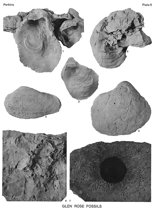
PLATE 6
Figs. 1-3 Crassostrea franklini camelina (Cragin). Oyster common in
Bed 2, Barker Branch section; Bed 18, Cedar Brake Camp; and Bed 2, Paluxy Townsite
(illustrated specimen)
1. Interior of large left (attached) valve with left valve of smaller specimen on right.
2. Exterior of large left valve showing clump of shells to which it is attached.
3. Interior of right (free) valve.
Fig. 4 Acromya sp. Mud-burrowing clam preserved as a steinkern. Common in Bed 2, Barker
Branch section; Bed 1, Cedar Brake Camp section; and Thorp Spring Member.
Fig. 5 Liopistha (Psilomya) banderaensis Whitney. Mud-burrowing clam preserved as a
steinkern. Common in Bed 2, Barker Branch section.
Fig. 6 Surface of bored, oyster-encrusted cobble. Bed 2, Paluxy Townsite section. Also see
Bed 18, Cedar Brake Camp section.
Fig. 7 Serpulid worm tubes encrusting a small carbonized branch; polished surface. Bed 6,
Barker Branch section. Specimen collected and prepared by R. W. Rodgers.
37
LOWER CRETACEOUS DINOSAUR TRACKS
NEAR GLEN ROSE, TEXAS
Wann Langston, Jr.
Introduction. Dinosaur tracks are the most striking evidence of these fascinating
creatures over much of the Lower Cretaceous Glen Rose outcrop in Texas. They have been
reported in at least 14 counties, but the best known examples are those exposed in the bed
of the Paluxy River near the town of Glen Rose in Somerville County (for a summary of
dinosaur track occurrences see Langston, 1974). Although their presence had been long
known to the local populace, the earliest scientific note of the Glen Rose tracks was
taken by Ellis W. ShuLer in 1917. Since Shuler's time, the tracks have been repeatedly in
the public press as well as in the technical literature. Examples have been excavated for
display in several museums including, among others, the American Museum of Natural History
in New York and the Texas Memorial Museum in Austin. During the Great Depression, tracks
were quarried and offered for sale along the highways near Glen Rose at $25.00 to $30.00
(it is said that business was not brisk). Dinosaur Valley State Park has been established
near Glen Rose for the purpose of protecting some of the more spectacular trackways.
Location and Accessibility. Dinosaur tracks are seen at several places over a
distance of several miles in the bed of the Paluxy River near Glen Rose. Dinosaur Valley
State Park, situated astride the river channel, includes tracks in the middle part of
these exposures. The park can be reached via Park Road 59 which branches from State
Highway 205 about 2.8 miles west of Glen Rose. Other tracks in the area must be reached
either by walking up (or down) the river bed or by crossing private land for which
permission of the owners is essential.
38
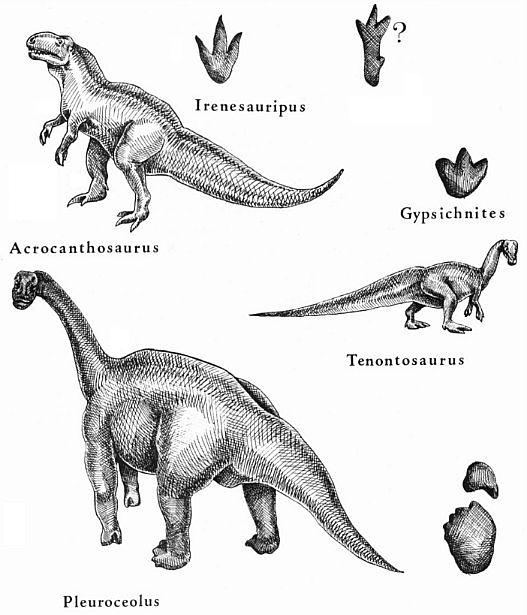
Figure 11. Glen Rose tracks and possible track makers Three-toed
tracks with sharp "heels", slender toes and claw marks (Irenesauripus)
were made by carnivorous dinosaurs, possibly Acracanthosaurus; "fleshy"
three-toed tracks (Gypsichnites) were made by ornithopods, possibly Tenontosaurus
and (or) Iguanodon. Huge fore- and hind-foot couplets are by sauropod dinosaurs,
probably Pleurocoelus. The problematical track may have been made by a carnivorous
dinosaur which sank into softer than usual mud.
Drawings by Sandra Langston.
40
The river flows intermittently (sometimes torrentially) and tracks
are reachable only at low water. However submerged tracks may be seen from the river banks
when the water is clear.
Nature of the Tracks. Dinosaur tracks in Texas are of two general forms (Fig. 11).
Most common are three-toed types which are divisible into those with long slender toe
marks, sharp heels, and frequently, distinct claw marks, and others with blunter,
"fleshier", and more widely spread toes lacking distinct claw marks. The
slender-toed tracks are usually attributed to carnivorous dinosaurs (carnosaurs). Similar
tracks from the Lower Cretaceous of British Columbia have been called Irenesauripus
and those from Texas originally described under the name of Eubrontes? glenrosensis
by Shuler are better assigned to Irenesauripus. These tracks may attain large size
with lengths exceeding 26 inches. Such large tracks may have been made by a big carnosaur Acrocanthosaurus
atokensis whose skeletal remains have been found in Oklahoma and Texas Antlers sand
deposits.
The blunt-toed tridactyl tracks were originally described under the name of Eubrontes?
titanopelopatidus, but, again, these show closest affinities with Lower Cretaceous
tracks in British Columbia named Gypsichnites. These tracks vary considerably in
size, ranging in length from less than 12 inches to more than two feet. Gypsichnites
tracks were probably made by ornithopod (bird footed) dinosaurs. They are enigmatic,
because while all clear ornithopod tracks in Texas are three-toed, the ornithopod most
abundantly represented by skeletal remains in this region, Tenontosaurus, had four
claw-bearing digits on the hind feet. Thus one might expect to find some trace of the
fourth toe, although possibly this toe was so short that it would have registered only in
the softest mud.
42
Very large Gypsichnites tracks could hardly have been made by
any known species of Tenontosaurus, which rarely exceeded 20 feet in body length. A
big ornithopod, Iguanodon, well known in European Lower Cretaceous deposits had a
massive three-toed bird-like foot. Iguanadon skeletal remains have recently been
recognized for the first time in North America (Utah) and it is therefore possible that
the big ornithopod tracks in Texas were made by an Iguanodon whose remains have not yet
been found in the terrigenous Glen Rose equivalents in this part of the country.
The second type of track found in Texas are the spectacular footprints of the giant
amphibious (sauropod) dinosaurs, commonly called brontosaurs. These tracks have not yet
received a formal ichnological name, but it is not improbable that they were made by the
Lower Cretaceous sauropod Pleurocoelus whose remains are the only ones of the group
so far reported in Texas.
Sauropods were quadrupeds and hence produced both fore and hind footprints. The fore
prints of the Texas sauropod are unusual in lacking any trace of a claw. All known
sauropod skeletons show a single claw on the front foot, but the condition in Pleurocoelus
is unknown, a complete fore foot skeleton never having been found. The hind footprints are
also unusual, showing evidence of four claws whereas the usual number in sauropods is
three. However, a fragmentary sauropod foot skeleton from North Central Texas, possibly
belonging to Pleurocoelus, contains a fragment of a fourth claw (Gallup, 1975).
While the above descriptions apply generally to dinosaur tracks in the Lower Cretaceous
deposits all over Texas, all of the forms are present in the vicinity of Dinosaur Valley
State Park. Most of these tracks occur in series called trackways. The amount of
information to be derived from single tracks is limited, but trackways provide much more
43
insight into the nature of the animals, and what they were doing.
Thus the most famous set of trackways at Glen Rose suggests a fascinating story.
Here a trail of carnosaur tracks ran parallel to a series of about 25 front and hind
footprints of a big sauropod. The sauropod trail bends to the left and so do the tracks of
the carnosaur. At some places the carnosaur tracks are superimposed on those of the
sauropod and all tracks are equally fresh. It seems likely that the carnosaur was
following close behind the sauropod, possibly walking along with it. One cannot help
speculating about what ultimately happened. Unfortunately, the trackways disappear beneath
the bank of the Paluxy River, so unless someone is willing to take a chance, and likes to
dig, what transpired at the end of the trail will remain unknown.
Excavation of the Tracks. This trackway, it was thought, would be a great
attraction if it could be removed and assembled beneath the skeleton of the giant
brontosaur at the American Museum. Accordingly, it was decided in 1940 to excavate not
only the individual tracks, but also all of the intervening rock between. Removal was
carried out that year under the supervision of the late R. T, Bird, as a cooperative
project of the American Museum of Natural History and the Texas Memorial Museum (Bird,
1941). The project which took about five months was partly financed by the federal Works
Progress Administration (WPA) and the Sinclair Oil Company, which at that time had a
vested interest in big dinosaurs...remember the sign of the great green brontosaur!
First, the trail was uncovered for a length of about 40 yards (Fig. 12). At the time much
of it was under water so a sandbag dike was built around the trackway and the water bailed
out. No pumps were available so man-power and buckets were used. A rate of about 12
barrels of water per minute was achieved, but recurrent flooding and the need for repeated
bailing caused much loss of time during the project (Bird, 1954).
44
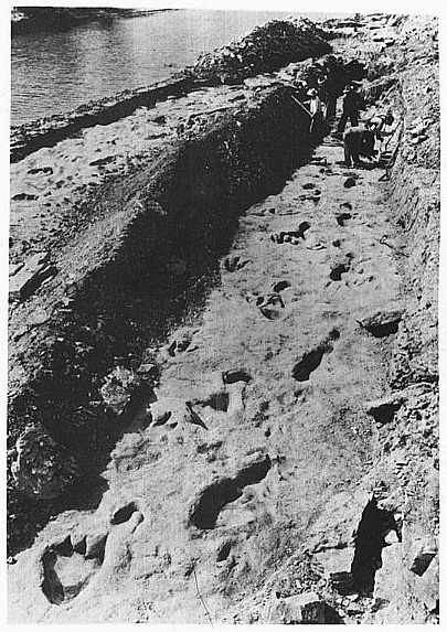
Figure 12. Parallel sauropod and theropod trackways in Paluxy Creek,
Dinosaur Valley State Park, near Glen Rose, Texas. Scene just prior to excavation and
removal of trackways in 1940. The men are working in the segment sent to the Texas
Memorial Museum in Austin. Tracks in the foreground were reassembled beneath the
brontosaur skeleton in the American Museum of Natural History, New York. (By permission,
School of Geoscience, Louisiana
State University, Baton Rouge)
45
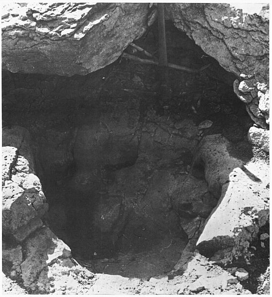
Figure 13. Right hind footprint of a sauropod showing massive
pressure ridge squeezed up around the edges when the foot sank into stiff lime mud.
46
The track bearing stratum was about 16 inches thick and rested upon a
layer of clay. The rock was highly jointed and fairly soft so it could be easily broken
and cut into smaller pieces. Each block of rock (there were some 1,200 blocks and several
thousand smaller pieces in all) was numbered and carefully mapped. Edges of the blocks
were protected by layers of burlap dipped in plaster. For this about 1,500 gunny sacks and
a ton of plaster were used. An estimated 40 tons of rock were removed, about half going
each to the American Museum and to the Texas Memorial Museum, with the remainder ending up
at several other places (U. S. National Museum, Shuler Museum at SMU, Texas A & M, and
Princeton). Incidentally, all of this work was done by back-breaking labor without the aid
of dozers, jack hammers, or hoists, tractors or other mechanical aids.
Once received at the museums, the pieces of this three-dimensional jigsaw puzzle were
reassembled with all the blocks tightly refitted and imbedded in a base composed of about
four tons of plaster and countless bales of excelsior. Both parts of the trackway are
still on display in New York and Austin and constitute the most spectacular exhibits of
their kind anywhere in the world.
Geological Setting of the Glen Rose Dinosaur Tracks. The Glen Rose Formation in the
Paluxy River area is part of a wide spread Lower Cretaceous transgressive-regressive
depositional sequence in the Trinity and Fredericksburg divisions of the Comanche Series
(L~te Aptian to Middle Albian Age). The terrigenous shore facies above and below the Glen
Rose Limestone, designated, respectively, the Paluxy and Twin Mountains Formations,
coalesce up-dip to form an undifferentiated basal Cretaceous unit variously termed the
Antlers, Trinity or Basal sands.
47
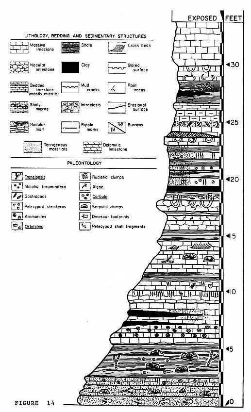
Figure 14. Measured section of Glen Rose Formation showing
relationship of dinosaur track horizon at base to cyclical sequence above. Massive
limestone unit at top is the Thorp Spring Member. Location of section, 2.2 miles west of
Glen Rose at confluence of Paluxy
River and Barker's Branch. This section is similar to but not identical with the section
in the bed of the Paluxy River in Dinosaur Valley State Park. The track bearing bed can be
traced for considerable distances, but the overlying section is highly variable laterally.
48-49
Dinosaurs and associated fossil vertebrates in this unit are
approximately correlated with the Arundel Formation in Maryland and the District of
Columbia, and the Cleverly Formation in Montana. The dinosaur tracks near Glen Rose occur
in the lower member of the Glen Rose Formation as developed here.
The tracks occur in dolomitic sandstone which is overlain by a clayey biomicrite with
cross bedding, rip-up clasts and plant fragments (Fig. 14). They are about six feet below
a regional marker known as the Corbula bed (which actually consists of several Corbula
concentrations). The beds above the track horizon also contain dasycladacean alga, Porocystis,
and small patches of serpulid mounds.
According to Nagle (1968) the Glen Rose sequence in Central Texas represents a cyclical
alteration of subtidal through supratidal facies in which the cycles are mainly
regressional, resulting from progradation of the shoreline. The cycles are recorded as
successive sedimentation units deposited within a marginal marine hypersaline lagoon or
bay system. Seven cycles preserved in the Paluxy Valley include subtidal to
supratidal-flat deposits, marsh floodplain, shoal patch reef, bay, marsh island and
shifting sand lobe deposits. Despite this seeming regularity, the alternating soft and
hard strata typical of Glen Rose lithology are highly variable laterally and correlations
over more than a few miles are very uncertain.
How the Glen Rose Tracks were Made. The area around Glen Rose was, during much of
Comanchean time, situated on a broad shelf, up to 300 miles wide, that bordered the Lower
Cretaceous Gulf of Mexico from southern Florida to Monterrey and beyond. The outer margin
of this shelf was separated from the open sea by a great barrier reef complex consisting
of rudist banks, algal masses, etc. (Young, 1972).
50
Behind the barrier deposition was slow and dominated by carbonate
sediments. Widespread algal mats and frequent serpulid mounds attest to the shallowness of
the waters toward the shore where the carbonates were mixed with clay and sand which
produced broad mud flats. Several times reef growth restricted communication between
lagoon and open sea, but long periods of quiet were punctuated from time to time by
tropical storms which either breached the barriers or withdrew water from the lagoons.
During these latter episodes, the shallow shelf waters receded temporarily, further
lowering the water level or even exposing wide areas of mud flats completely. It was at
such times that dinosaurs, walking individually or in groups or herds, left their tracks
in the stiff lime mud and algal mats.
The consistency of the mud differed from place to place, hence the quality of tracks is
highly variable. Some are so sharp that they reveal details of the foot structure whereas
others can be identified as tracks only by their sequential arrangement and regular
spacing of indistinct depressions in the rock. Sauropod tracks are often bordered by thick
pressure ridges where the mud was squeezed up around the foot (Fig. 13). Oblong
impressions sometimes with three radiating grooves at one end are probably collapsed
three-toed tracks formed when a dinosaur, stepping into very soft mud, sank more deeply
than usual, and then relaxed the foot as it was withdrawn. Only the tips of the toes with
their claws left recognizable marks, lacking which these tracks would hardly be
identifiable. Interestingly, some of these tracks show what may be a trace of a fourth toe
which in some carnivorous dinosaurs was placed high on the shank and would not normally
touch the ground. R. T. Bird has observed that similar tracks on a much smaller scale can
be produced by chickens walking on extremely soft deep mud!
51
When the uaters returned to the lagoon many of the tracks were
quickly filled by fine terrigenous sediments which may have been carried into the bay by
inland flooding
possibly caused by torrential rains associated with the same storm systems that had
lowered the water level in the lagoon originally. Other tracks apparently survived for
weeks or even months or years and filled only gradually as modern footprints do in some of
the Florida lagoons, for example.
Dinosaur Food. Since the greater proportion of dinosaurs making tracks at Glen Rose
were vegetarians, it is of interest to know what plants may have been available to them
for food. Plant remains derived from various biotopes are present in most Glen Rose units
in and around the Park (Kessler, 1968). Megafossils are, however, but spottily represented
and are mostly associated with supratidal and marsh deposits. This part of the flora has
not been studied in detail, but the following genera have been identified: Equisetum,
Sphenopteris, Dioonites, Podozamites, Zamites, Abietites,
Pinus, Brachyphyllum, Frenelopsis, and Sequoia. A florule
containing Araliaephyllum, Sapindopsis and Cinnamomum has been
recorded from the slightly younger Paluxy sands a few miles from Glen Rose, near
Stephenville.
A diverse and abundant microfossil flora in the Glen Rose Formation described by Kessler
shows strong similarities to Early Cretaceous floras in England, Maryland and Virginia.
Present are 49 genera of pollen and spores and 13 genera of "hystrichospheres"
(dinoflagellates and acritarchs). In a measured section near the Park, gymnospermous
palynomorphs comprised about 29 percent of the fossil assemblage. Of this group, the
Coniferales are most abundant, and include such forms as Inaperturopollenites, Spheripollenites,
Araucariacites, Classopollis, and Sequoia as well as the bisaccate
genera
52
Podocarpus, Abietineaepollenites, and Pinus. Ephedripites
is present. A cycad, Entylissa was also recognized. Angiosperms comprising about 9
percent of the palynomorphs are dominated by Tricolpopollenites, Tricolporopollenites,
Quercus, and Liliacidites. There are also small percentages of ferns,
including the family Schizaceae.
It is reasonable to suppose that some species of dinosaur track makers fed upon the plants
of this flora. However, nothing is known about dinosaurian dietary preferences. Some
recently revived speculation about a possible role played by tannins and alkaloids in the
extinction of the dinosaurs attempts to correlate this event with the appearance of
flowering plants (Swaim, 1974 and Wieland, 1925). However, the association of angiosperms
and dinosaurs in the Glen Rose beds shows that the two groups were co-evolving in Albian
time, millions of years before the dinosaurs' demise.
On Identifying and Naming Dinosaur Tracks. Paleontologists are accustomed to
comparing morphology...if two specimens appear essentially alike, they are assigned to the
same
species. But there are instances where morphology is inadequate to distinguish remains of
species or genera that may have been quite distinct in life. These are the so-called form
genera or form species of paleontology. The problem of form taxa is familiar to
paleobotanists and palynologists and it is in the study of animal tracks and trails
(ichnology) that the concept is most widely applied to fossil vertebrates. Everything
about an animal track is variable. The same animal moving across a soft muddy bottom would
leave a different kind of track than it would produce when walking slowly (or running) on
a sandy beach. Tracks will differ depending on whether the animal was walking up or down,
or across a slope and whether in any of these situations it was accelerating or stopping.
53
Hence, one animal could be responsible for several different
ichnospecies or ichnogenera as the form taxa of tracks are called.
The naming of ichnogenera and species conforms in general to the International Rules of
Zoological Nomenclature (similar, but not identical to the rules governing botanical
nomenclature). Hence an ichnospecies has a binomial name and the general rules of priority
apply. The practice, often indulged in by early workers, of giving names to individual
footprints is now discouraged. Series of tracks constituting trackways furnish much more
infermation than single tracks, sometimes providing data on the variability of tracks made
by a single animal.
Another problem with tracks is the identification of the track maker. At Glen Rose there
has been a tendency to ascribe the large three-toed tracks to "Trachodon"'
or Tyrannosaurus rex, the sauropod tracks to "Brontosaurus"
in spite of the fact that the actual track makers existed several million years earlier
than "Trachodon" or Tyrannosaurus, and several million years after
"Brontosaurus" (The names Trachodon and Brontosaurus are,
in any case, taxonomically invalid.) As noted earlier the form genera of Glen Rose tracks
may (or may not) be attributable to Tenontosaurus, Iguanodon, Acrocanthosaurus
and Pleurocoelus (Fig. 11). The tracks themselves, however, will never be
transferred taxonomically to any of these taxa.
54
REFERENCES
Bird, R.T., 1941, A dinosaur walks into the museum: Nat. Hist., vol. 47, pp.74-81.
1954, We captured a "live" brontosaur: Nat. Geog. Mag., vol. 105, pp. 707-722.
Gallup, M.R., 1975, Lower Cretaceous dinosaurs and assoclated vertebrates from
North-Central Texas in the Field Museum of Natural History: Univ. Texas at Austin, M.A.
thesis, 159 p.
Kessler, L.G., 1968, Palynology and paleobotany of the Glen Rose Formation, North and
Central Texas: Univ. Texas at Austin, M.A. thesis, 168 p.
Langston, W., Jr., 1974 Nonmamalian Comanchean tetrapods: Geoscience and Man, vol. 8, pp.
77-102.
Nagle, J.S., 1968, Glen Rose cycles and facies, Paluxy River Valley, Somervell County,
Texas: Tex. Bur. Econ. Geol., Circ. 68-1, 25 p.
Shuler, E.W., 1917, Dinosaur tracks in the Glen Rose Limestone near Glen Rose, Texas:
Amer. Jour. Sci., vol. 44, pp. 294-298.
Swaim, T., 1974, Cold-blooded murder in the Cretaceous: Spectrum, vol. 120, pp. 10-12.
Wieland, G.R., 1925, Dinosaur feed: Sci., vol. 61, pp. 601-603.
Young, K.P., 1972, Cretaceous paleogeography: implications of endemic ammonite faunas:
Tex. Bur. Econ. Geol., Circ. 72-2, pp. 1-13.
55