| About the Author & Website Editor: Dr. Bruce Cornet is a Geologist, Palynologist, and Paleobotanist. | New Jersey Geomorphology A rollback in Time |
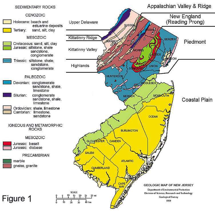
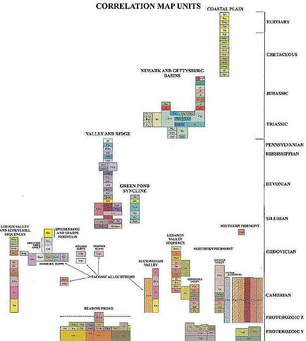
The State of New Jersey, unlike many states, contains rocks of many ages ranging from Precambrian gneiss, granite, and marble of Proterozoic Y and Z Eras (middle and late, respectively), Paleozoic Era, Mesozoic Era, Cenozoic Era, and Holocene (Recent) sediments. Overall, the rocks of these different Eras are distributed across the state from north to south according to age, although the order is reversed in the New Jersey Highlands due to thrusting of deeper and older Precambrian rocks over younger Paleozoic rocks (see cross sections below). The only significant gaps in time (i.e. Periods and Epochs not represented in outcrop) are earliest Cretaceous (pre-Albian), Middle and Late Jurassic, Early and Middle Triassic, Permian, Proterozoic X, and the Archean and Hadean Eons (the oldest rocks on Earth). Examples of rocks dating back to at least 1 billion years are represented in New Jersey.
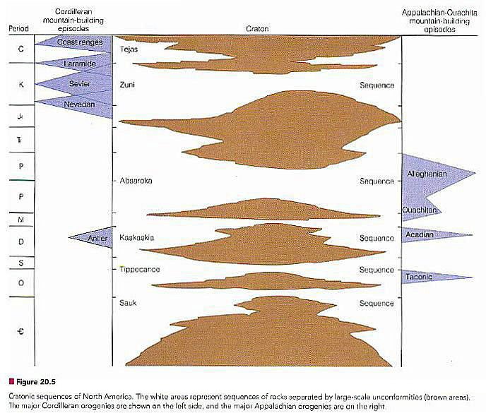
There are three mountain building episodes recorded in the rocks of New Jersey. Each represents a time when the African and/or European continental plates crunched into the North American plate during a period of ocean basin closure and the subduction of oceanic crust beneath the North America plate - similar to what is occurring today in the Himalayan and Alpine regions of Asia, India, and North Africa. Thus, the eastern margin of the North American plate contains accreted slices of Africa and Europe under younger deposits of the Piedmont and Coastal Plain (exotic allochthons). When you go to the New Jersey shore, realize that deep under your feet, below structures, you are actually standing over rocks which were once part of Africa (see right sides of Cross sections B-B' and C-C' below).
West Coast East Coast
From Monroe and Wicander, 2006, The Changing Earth, Exploring Geology and Evolution, Forth
Edition.
Three Phases of Mountain Building Recorded in New Jersey
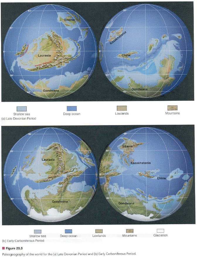
The first mountain building episode occurred
during the Early Paleozoic. It created the Taconic Highlands (Taconic orogeny) or
present day Berkshires.
From Monroe and Wicander, 2006, The Changing Earth, Exploring Geology and Evolution, Forth
Edition.
The second mountain building episode
occurred during the Middle Paleozoic. It created the Baltic Mountains in Northern
Europe, the southern extent of which caused compressional thrusting, folding, and uplift
in northern New Jersey (Acadian orogeny). To the north in New York State the
enormous Catskill (fluvial) delta developed to the west of the Acadian Mountains, the
roots of which lie deep below Piedmont and Coastal Plain sediments of eastern New
Jersey. The rocks of the Catskill Delta were subsequently uplifted during the Late
Paleozoic to form the Catskill Mountains of New York. The Acadian orogeny resulted
in the European continental plate being attached to the North American plate.
From Monroe and Wicander, 2006, The Changing Earth, Exploring Geology and Evolution, Forth
Edition.
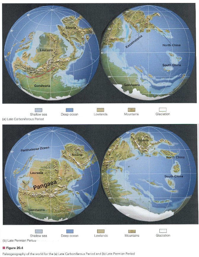
The third mountain building episode occurred
during the Late Paleozoic. It created the Appalachian Mountains, and resulted in the
African continental plate being attached to the North American plate to complete the
formation of the Supercontinent Pangea.
From Monroe and Wicander, 2006, The Changing Earth, Exploring Geology and Evolution, Forth
Edition.
AD: Are you worried about HIT-001
braindumps exam & 642-447
preparation? We offer up-to-dated pmi project
management test and 642-457 with
100% exam pass guarantee of CHECKPOINT training.
[12.24.14-17]
What You Need To Know
The major geologic provinces of New Jersey as indicated in Figure 1, and
where they are located.
a. Appalachian Valley & Ridge Province.
b. New England Province (Reading Prong).
c. Piedmont Province.
d. Coastal Plain Province.
The four geomorphic features of Northern New Jersey, and where they are
located.
a. Upper Delaware.
b. Kittatinny Ridge.
c. Kittatinny Valley.
d. Highlands.
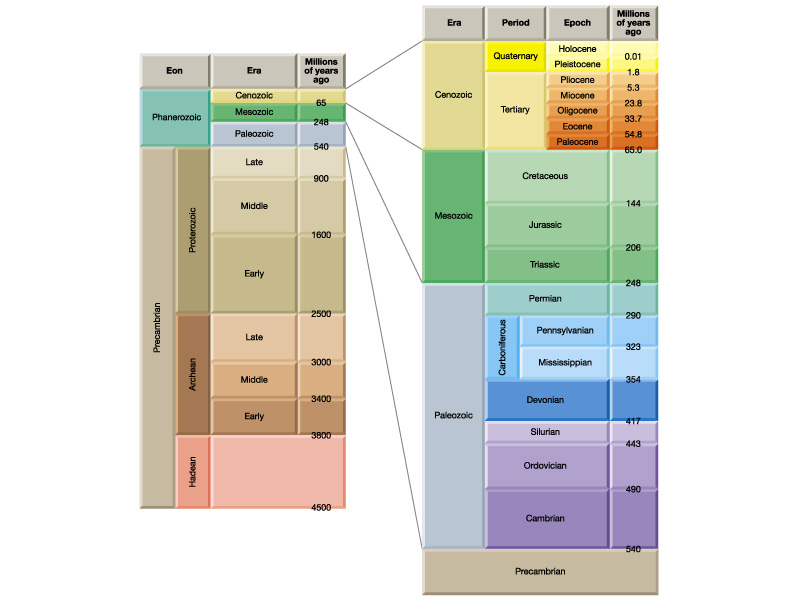
The 11 Periods of geologic time represented in New Jersey,
and the Eras to which they belong.
From youngest down:
a. Holocene
b. Tertiary
c. Cretaceous
d. Jurassic
e. Triassic
f. Mississippian + Pennsylvanian (= Carboniferous in Europe).
g. Devonian
h. Silurian
i. Ordovician
j. Cambrian
j. Precambrian
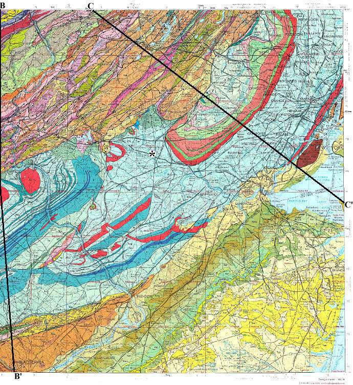
Two "Prongs" extrend south into New Jersey from the New
England Province (Cross section C-C'). They are narrow
bands (prongs) of early Paleozoic and Precambrian rocks that represent thrust fault
"riders", or elongate segments of basement rock that were thrust up to their
present relative position at the surface (a product of erosion and exposure) along thrust
faults during the Taconic and Acadian orogenies.
a. The Reading Prong, which contains metamorphosed rocks of
Silurian and Ordovician age, as well as of Cambrian and Precambrian age.
b. The Manhattan Prong, which contains metamorphosed rocks of
Cambrian-Ordovician and Precambrian age, including the Inwood Marble and Manattan Schist
(actually a phyllite), which are intruded by the Cordlandt igneous complex. The
Manhattan Prong is situated just east of the Newark basin along the Hudson River, while
the Reading Prong is situated just west of the Newark basin, and forms the footwall block
to its border fault (see Cross section C-C' below).
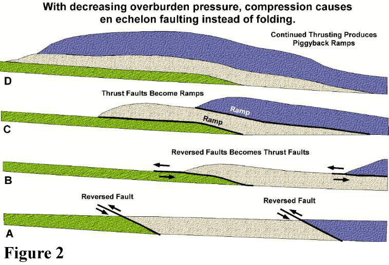
How thrust faults or reversed faults are formed in a compressional tectonic regime (mountain building episode in a convergent plate environment), and why these faults flatten out with depth to join horizontal faults called "decolements" or detachment zones. Such faults are also called listric faults (from listron, Gr. for leveling or shovel), because they start out steep, are curved, and level out with depth (following the path a shovel makes). See Figure 2.
How ancient listric faults can become the border faults to half grabens during a subsequent extentional tectonic regime (rift valley episode in a divergent plate environment). This is what happened during the formation of the Newark basin, which crosses the midsection of New Jersey (see Cross section C-C' below).
Why the oldest rocks in New Jersey (New England Province) are sandwiched between younger Paleozoic rocks of the Appalachian Valley & Ridge Province, and Mesozoic rocks of the Piedmont and Coastal Plain provinces. They are called accretionary wedges and exotic terranes.
Study the maps, geologic key, cross sections, and figure, and read the information provided below.
 |
A Detailed Geologic Map of New Jersey
Click on map below for a large legible version (it may take a little time while for all the map segments to download). The asterisk in the middle of the map represents the location of Raritan Valley Community College. Taken from GEOLOGIC MAP OF THE NEWARK 1o x 2o QUADRANGLE, NEW JERSEY, PENNSYLVANIA, AND NEW YORK, by Peter T. Lyttle and Jack B. Epstein, 1987, U.S.Geological Survey, Denver, CO.
 |
 |
For an additional online geologic map that continues the geology of New Jersey north of the map provided above, go to Bedrock Geology of the Goshen-Greenwood Lake Area, N.Y. Field Trip stops 5 and 6 include this region. This map shows the area around High Point, NJ, as well as the southern part of the Wallkill River Valley in New York. The compressional regime dominated by thrust faults in New Jersey gives way to much less deformed Cambrian-Ordovician rocks that make up much of the Wallkill River Valley between Warwick and Goshen, NY.
Compressional Tectonic Regime. In the cross sections below (located on the map above) the rock structure beneath New Jersey can be seen as a series of "piggyback" ramps or riders, each of which has been thrust on top of the sequence in front of it, creating an accordion-like pile of thrust plates. Instead of each unit folding into anticlines and synclines, reversed faults develop, which allowed the posterior unit to be pushed up and on top of the anterior unit (see Figure 2 below). Think of a train reck in which the cars end up piled one on top of another. This process of compressional thrusting results in foreshortening of the sequence. That is, an entire unit can be compressed into a smaller geographic area by increasing the height of the rock pile. That height change we recognize as uplift or mountain building.
From map by Lyttle and Epstein, 1987.
 |
Extensional Tectonic Regime. In the cross sections above and below the Newark basin was formed when Pangea began to break apart 230 million years ago. Initially the Mantle beneath the area of incipient rifting began to heat up. With that heating there was rock expansion. As a balloon is inflated, the rubber expands and stretches. As the crust was uplifted and stretched due to Mantle "inflation", the rocks beneath New Jersey were slowly pulled apart along the very same reversed faults that had created the "piggyback" stack of thrust plates. Not all of the former reversed faults were reactivated - only one or two which extended north and south for the longest distance. These faults became normal faults that defined the western boundary of the Newark basin. The listric shape of the fault dictated that the rocks under the Newark basin (called "basement" rocks) would slide down into the crust in a predictable geometric fashion, forming what is called a "half graben". A half graben is half of a "full graben", which means that it contains only one border fault instead of two opposing faults on either side of the graben (basin). The shape of a half graben is a wedge, because areas closer to the border fault subside more than areas further away from the border fault inside the basin that is formed. The cross section of the Newark basin below is not accurate due to vertical exaggeration. It should be wedged-shaped with the thickest portion on the left.
From map by Lyttle and Epstein, 1987.
 |
Accretionary Wedges and Exotic Terrane. Why is the crust below New Jersey so complicated? During each of the three mountain building orogenies during the past 500 million years, new crust has been added onto the North American plate through accretion. Most of that crust is former oceanic and island arc material, but some of it is derived from pieces of the African plate that remained attached to the North American plate when Pangea broke apart. These pieces of ancient oceans, island arcs, and Africa are called Exotic Terranes.
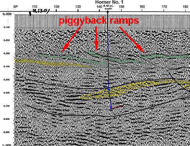
Below is an actual example of piggyback ramps in the Richmond basin (Triassic) of Virginia, which contains some of the oldest strata in the Newark Supergroup (rift valley basins along the East Coast of North America). The location of the Horner No. 1 well, the first well Dr. Cornet drilled in 1981, is shown on the seismic line.
This page was created on 27 October 2003.
This page was last modified on 11/24/2014.