Hueco Tanks Pluton and Sill
and Permian Carbonate Complexes,
West Texas
Table of Contents
Introduction
Geologic History
Tertiary Intrusion and Extrusion
Cross sections of Hueco Tanks stratigraphy
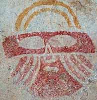
The Hueco Tanks pluton is located in the Hueco Tanks State Historic Site at the end of Hueco Tanks Road No. 1, El Paso, TX. "This 860.3-acre park is named for the large natural rock basins or "huecos" that have furnished a supply of trapped rain water to dwellers and travelers in this arid region of west Texas for millennia." "A unique legacy of lively and fantastic rock paintings greets the visitor at the "tanks." From Archaic hunters and foragers of thousands of years ago to relatively recent Mescalero Apaches, Native Americans have drawn strange mythological designs and human and animal figures on the rocks of the area. The site's notable pictographs also include more than 200 face designs or "masks" left by the prehistoric Jornada Mogollon culture. Hueco Tanks was the site of the last Indian battle in the county. Apaches, Kiowas, and earlier Indian groups camped here and left behind pictographs telling of their adventures. These tanks served as watering places for the Butterfield Overland Mail Route."
http://www.tpwd.state.tx.us/park/hueco/
During the early-middle Permain the supercontinent of Pangea had not completely formed. The North American plate was moving towards the east and beginning to collide with the African and Eurasian plates along an active subduction zone. To the west of that subduction zone the Ouichita and Appalachian mountains were forming, and contained numerous volcanic centers along a continental volcanic arc. The western side of the North American plate was the location of a passive continental margin - much like the one that exists today along the East Coast of North America. To the west of that passive margin was a volcanic island arc marking the location of a much older convergent/subduction area between a mid-Pacific spreading center and the continental plate. Along the tropical southwestern portion of the North American plate were linear reef complexes that developed at several seaward edges of the continental shelf, and extensive back reef lagoons dotted with small islands.
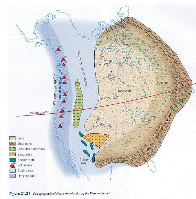
Figure 21.21 above from The Changing Earth, Exploring Geology and Evolution (Third Edition: 2001) by James S. Monroe and Reed Wicander.
| Period | Epoch | Age | When began |
Duration |
| Permian | Guadalupian (Middle Permain) |
Roadian | 270.6 | 2.6 |
| Cisuralian (early Permian) |
Kungurian | 275.6 | 5.0 | |
| Artinskian | 284.4 | 8.8 | ||
| Sakmarian | 294.6 | 10.2 | ||
| Asselian | 299.0 | 4.4 | ||
| Carboniferous | Pennsylvanian | Gzhelian | 303.9 | 4.9 |
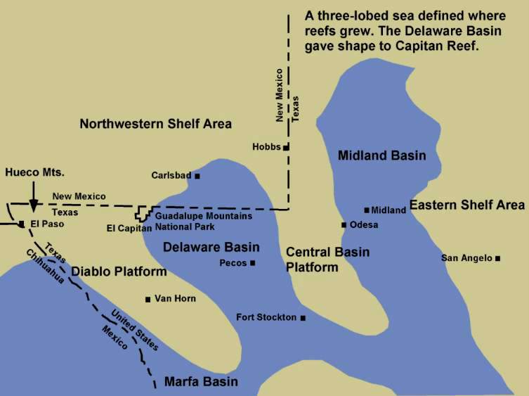
Three basins formed along the continental shelf: The Midland Basin to the east, the Delaware Basin in the middle, and the Marfa Basin to the west. They divided the sea floor into three deep areas separated by the Diablo and Central Basin platforms. The actual reef complexes formed at the edge of the continental shelf rather than back on the shelf due to an abundance of nutrients that flowed up from the continental rise and slope, upon which the filter-feeding reef organisms fed. Behind the reef complex a shallow carbonate platform existed beneath an extensive lagoon. Around small islands and near the paleoshoreline reefs also developed where wave action and water currents brought plankton and nutrients to reef builders and inhabitants.
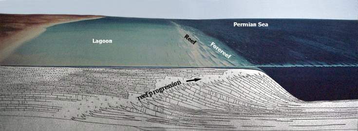
Image from Guadalupe Mountains National Park visitor center
Reef facies during the Permian were characterized by the following types of organisms: algae (e.g. Collenella and Mizzia), fenestellid bryozoans, ramose bryozoans (e.g. Acanthocladia), fusulinids (e.g. Polydiexodina) and other foraminifera, several types of sponges (e.g. Amblysiphonella, Cystauletes, Girtycoelia, Heliospongia, and Lemonia), Tubiphytes, productid brachiopods, cephalopods, and corals.
http://www.palaeos.com/Paleozoic/Permian/Capitanian.html
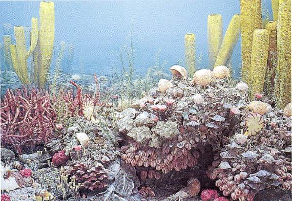
Figure 22.11 above from The Changing Earth, Exploring Geology and Evolution (3rd Edition: 2001) by James S. Monroe and Reed Wicander.
Fusulinids - large rice-grain-shaped foraminifera from the back-reef lagoon area of the West Texas Permian sea.
The back reef complex was populated by different types of bottom dwellers, including common crinoids, very abundant fusulinids (unusually large foraminifera), gastropods, cephalopods, and small corals. Crinoids (sea lilies) were thought to be extinct until they were found living in some of the deeper parts of the ocean. Because they were first known as fossils, living sea lilies are called "living fossils". The diagram below of marine life during late Mississippian Period looked a lot like that living in the back reef lagoon.
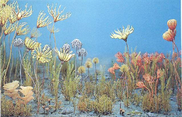
Figure 22.10 bove from The Changing Earth, Exploring Geology and Evolution (3rd Edition: 2001) by James S. Monroe and Reed Wicander.
Located near El Paso are the Hueco Mountains, which expose a significant thickness of back-reef carbonate deposits that formed on the Permian shelf. It is within those fossiliferous limestone sequences that Tertiary igneous intrusions occurred, which are in part responsible for the uplift, erosion, and exposure of the Permian lagoon deposits. Compressional folding and thrust faulting along the western side of the North American plate (when Pangea began to break apart during the Late Triassic and Early Jurassic) resulted in regional uplift and erosion/nondeposition of Triassic and Jurassic strata. That is why Cretaceous-age rocks sit unconformably upon Permian-age rocks in the southwestern U.S. One has to travel north as far as northern New Mexico, Arizona, and southern Nevada (further away from the edge of the plate) to find rocks of Triassic and Jurassic age preserved.
http://www.palaeos.com/Paleozoic/Permian/Capitanian.html
Permian shelf complexes for the Diablo Platform, Texas.
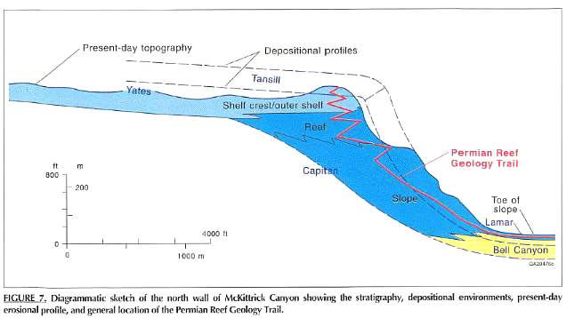
Figure 7 from Guide to the Permian Reef Geology Trail, McKittrick Canyon, Guadalupe Mountains National Park, West Texas (1993) by Don. G. Bebout and Charles Kerans, editors.
The Capitan Reef at the edge of the paleo-shelf.
Geologic map for the Hueco Tanks area. Click on map for map index key with geologic formations and ages.
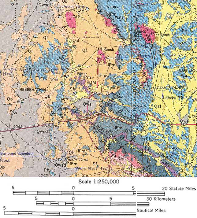
Click on map for map index key with geologic formations and ages. Pink represents Tertiary intrusions.
Tertiary Intrusion and Extrusion
A major change in the style of geologic movement occurred along the West Coast. "The Pacific oceanic crust changed its movement from collision and subduction to right-lateral shearing. This oblique movement signaled the beginning of extensional deformation in the area west of the Colorado Plateau. This area began to be literally pulled apart. The rocks were tilted, folded, and broken by faults during this deformation. Geologists believe that rocks that make up the Sierra Nevada were much closer to those of the Colorado Plateau in the early part of the Cenozoic time than they are today. In southern Nevada, total east-west extensional movement is estimated at about 150 miles. During the latter part of the Cenozoic (about the last 20 million years), extensional forces produced the mountain ranges and intervening valleys that are characteristic of the Basin and Range province. Nearly all mountain ranges in Nevada are bounded by at least one fault, and these faults are considered to be active, moving during major earthquakes every few thousand years." (Tingley et al., 2001). And with this extension and shearing, the crust became thinner. About 10.5 to 12 million years ago extensive volcanism and intrusion occurred along this zone of extension from the Big Bend area of Texas north through Nevada and California up to Oregon and Washington, where fissure eruptions produced extensive basalt flows that formed the Columbia River plateau.
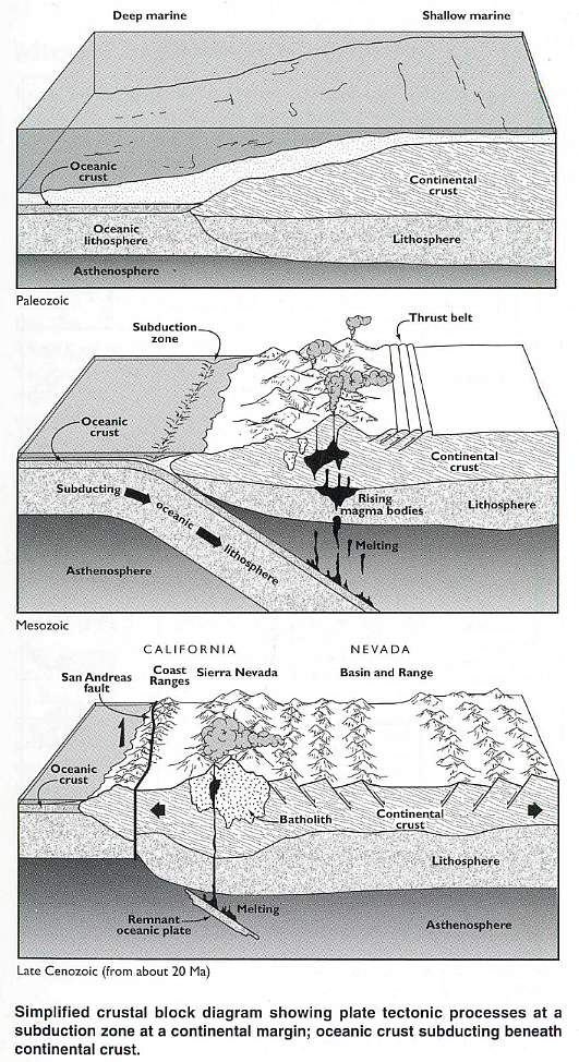
Above figure from Geologic Tours in the Las Vegas Area, Expanded Edition (2001) by Joseph V. Tingley, Becky W. Purkey, Ernest M. Duebendorfer, Eugene I. Smith, Jonathan G. Price, and Stephen B. Castor (Nevada Bureau of Mines and Geology, Spec. Pub. 16).
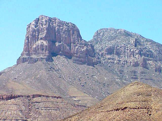
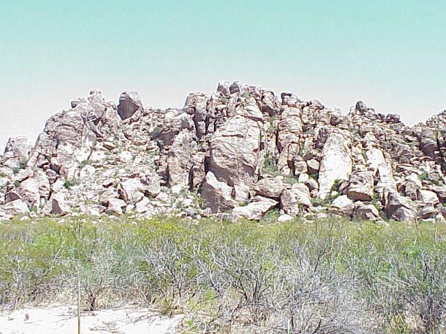
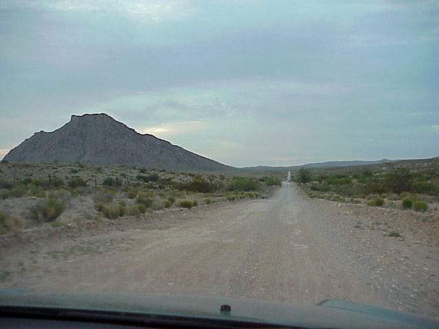
Below is the Hueco Tanks intrusive (Tertiary granite pluton) viewed from the south. Permian carbonates crop out in the Hueco Mountains in the background, along with an igneous sill that was once part of the Hueco Tanks igneous intrusion before erosion separated the outcrops. The vertical columnar jointing in the sill makes it stand out against the Permian fossiliferous limestones.

Permian Magdalena Formation and Hueco Limestone make up most of the mountain range in the background. On the left the Hueco Tanks sill can be seen in the middle of the mountain side. To the far right a portion of Cerro Alto Mountain can be seen. It is another Tertiary granite pluton exposed by erosion.
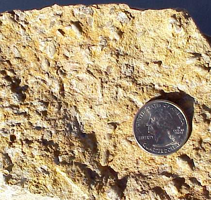
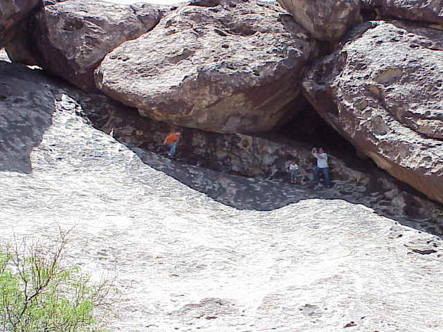
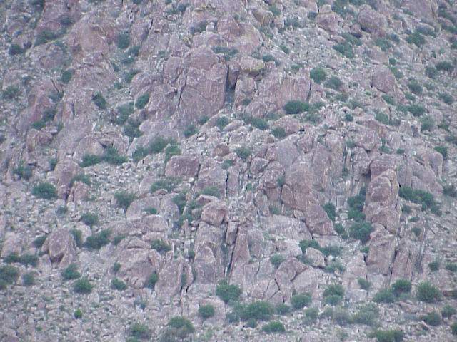
A close up of Hueco Tanks pluton, showing classic exfoliation weathering features that widened the joints in the granite, producing cavities and caves that act as water storage "tanks" following seasonal rains.
Close up of exfoliation features that widened the joints and produced the rounded shapes of granite blocks.
Cross sections of Hueco Tanks stratigraphy
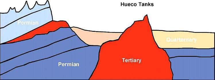
Back during the early Tertiary the entire area was covered by the marine Campagrande Formation of Cretaceous age (dark green), which can still be found around the flanks of the uplifted area. A small pluton intruded into Permian carbonates of the Magdalena Formation (dark blue) and younger Hueco Tanks Limestone (light blue). The intrusion caused uplift and erosion, which resulted in the removed the Campagrande Formation and Hueco Limestone, and part of the igneous sill on either side of the pluton. The distal portion of the sill is still present in the Hueco Mountains to the east of Hueco Tanks (see geologic map above).
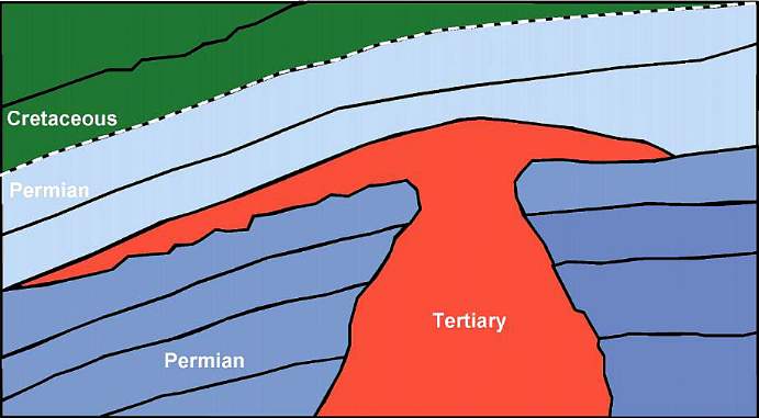
Following erosion Quarternary fluvial deposits filled in part of the valley where the Tertiary pluton is now exposed.
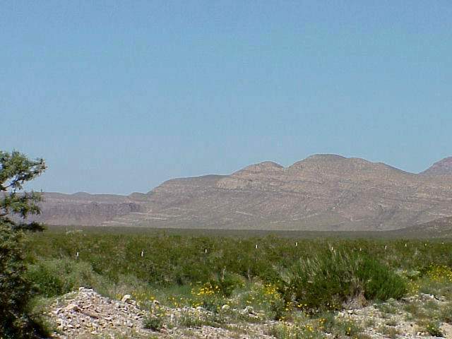
To the east of Hueco Tanks Cerro Alto Mountain (a Native American sacred mountain) sticks up defiantly, and represents another pluton that was intruded during the Tertiary at about the same time as the Hueco Tanks pluton. The picture below was taken on top of the Hueco Mountains looking north at Cerro Alto Mountain on the left.
Close up of the jointing in granite of the Cerro Alto pluton.
Web page by Bruce Cornet, Ph.D., El Paso Community
College.
Web page first created in September 2004; modified on 04/26/2005.