KARST |
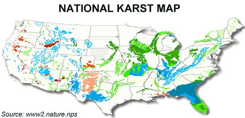
| What is Karst? Karst is a topographical landscape/terrain formed by the dissolution of soluble rocks (such as limestone, or dolomite, and to a lesser extent gypsum) by acidic water. Karst is a term that was originally applied to a plateau in the Dinaric Alps of Yugoslavia and has since become a common term around the world. Aquifers are often associated with karst, as are sinkholes, ground subsidence, disappearing streams, large springs, caves/caverns (such as Carlsbad Caverns), subsurface drainage, shafts, pitted rock surface, groundwater contamination and inconsistent water supply. About one-fourth of the world's water supply comes from karst aquifers. Karst topography constitutes 10% of the surface of the earth (20% for the U.S.), but about 25% of the world's population lives in these areas. Interestingly enough, some evidence shows that this trend was most likely preceded by early hominids (Australopithecines). In historic times exposed karst caves were used as shelters from the elements, and cave drawings are commonly found throughout the world, many of them in karst caves. Because underground streams often follow karst areas it is an important and valuable resource since groundwater constitutes only .625% of all fresh water sources worldwide. National Karst Map
KARST LINKS: The Karst Conservancy: http://www.karstconservancy.org/karst/what-is-karst.asp Dye Tracing: http://www.dyetracing.com/karst/ka01001.html Geological Survey of Ireland (karst page): http://www.gsi.ie/workgsi/groundwater/karstbook/01-what-is.htm NSS (karst page) www.caves.org/conservancy/ikc/karst.htm Karst Management Handbook Training (LEARN ABOUT KARST!): http://www.for.gov.bc.ca/hfp/fordev/karst_course/lesson1/1-2_what.htm
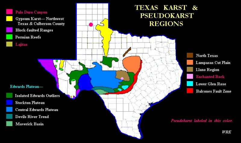
Texas Karst Map
Source: http://www.utexas.edu/depts/tnhc/.www/tss/tsskarstregionmap.htm
More on karst in Texas from the Texas Speleological Survey (TSS): http://www.utexas.edu/depts/tnhc/.www/tss/tsscavesandkarst.htm
|