Basal Jurassic Dinosaur Footprints, Fishes, and Plants
Whitmore Point Member of the
Moenave Formation,
St. George, Utah
Squatting Dinosaur Tracks at Johnson’s Farm in St. George,
by Nancy Carruthers, Utah Geological Survey
ugs / utah geology / dinosaurs & fossils /
squatting dinosaur
Table of Contents
Introduction
Location Map
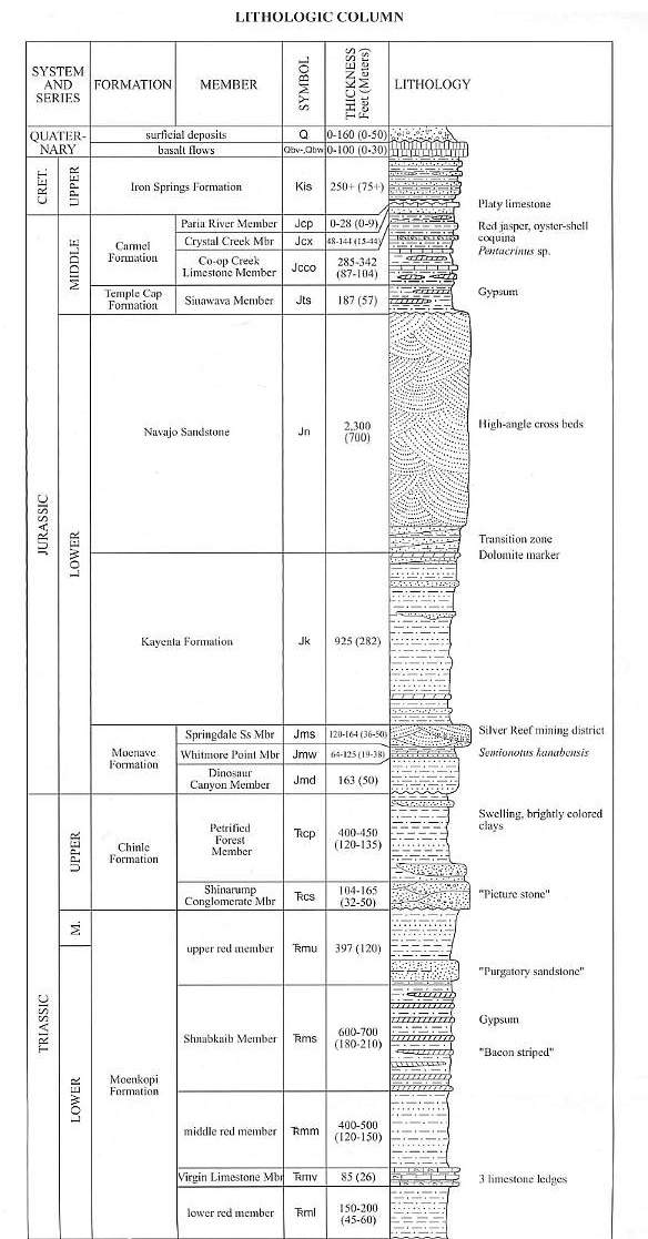
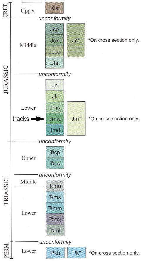
Triassic and Jurassic Stratigraphy and Nomenclature
Cross Section from Harrisburg Junction Quadrangle
Dinosaur Trackway Discovery
Why Are The Dinosaur Discoveries In St. George, UT, So Important?
Picture Gallery of Tracks, Plants, and Stratigraphy
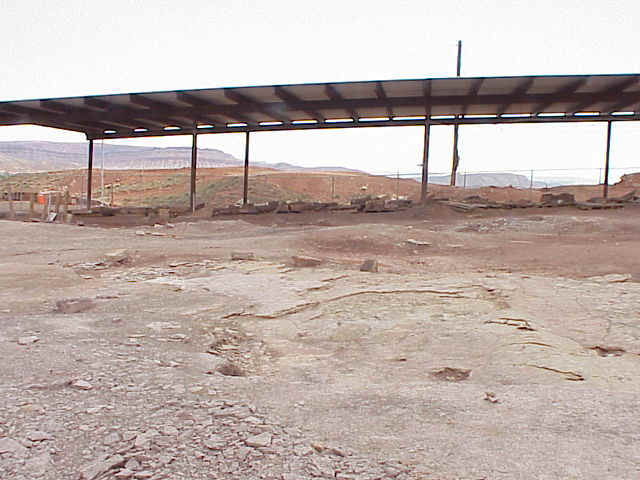
Temporary Specimen Shelter
Local Whitmore Point Member Stratigraphy
Whitmore Point Sedimentary Structures
Excavated Fossils
Squatting Dinosaur Tracks at Johnson’s Farm
Swimming Dinosaurs
Invertebrate Trackway from the Whitmore Point Member
Semionotus, a Fossil Fish from the Whitmore Point Member
Fossil Plants from the Whitmore Point Member
A Basal Jurassic Water Lily?
During this Early Jurassic Period, the land in the St. George area was at or near sea level since the Rocky Mountains had not yet begun to form. The location was close to the equator and all of the continents of Earth were attached into the supercontinent of Pangaea. Streams and lakes once covered portions of southern Utah and northern Arizona depositing the many rocks we now see in the St. George area. An enormous freshwater lake called "Lake Dixie" once covered this area during the Early Jurassic period. The St. George Dinosaur Discover Site at Johnson Farm is contained within the Moenave Formation, which consists of sequences of sandstone, mudstone, siltstone, and shale. The Moenave overlies the Upper Triassic Chinle Formation and underlies the Lower Jurassic Kayenta Formation that forms the red cliffs above St. George. Information taken from http://www.sgcity.org/dinotrax/fossilfinds.php
Above photographs courtesy of James I. Kirkland and Paul E. Olsen. Lower painting by Mark Hallett.
Only one other area in North America preserves as many trackways as at the Johnson Farm, but it is located on the opposite side of the United States in Connecticut. The Rocky Hill Dinosaur State Park was created after excavation turned up (uncovered) similar age trackways in an ancient, Early Jurassic lake bed (East Berlin Fm.) in the Hartford basin of Connecticut and Massachusetts. See the East Coast dinosaur park at http://www.dinosaurstatepark.org/.
Early Jurassic footprints and trackways in the East Berlin Fm., Hartford basin, at the Rocky Hill Dinosaur State Park, Connecticut. Courtesy, Paul E. Olsen.
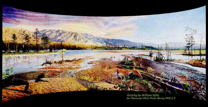
Diorama of the Hartford basin, showing a diverse Late Triassic landscape just before major floral and faunal disruption at the Triassic-Jurassic boundary. Courtesy, Paul E. Olsen. Painting by William Sillin.
Diorama of the Hartford basin, showing an Early Jurassic landscape just after major floral and faunal disruption at the Triassic-Jurassic boundary. Note flood basalts of the Newark Supergroup rift in the foreground. Unlike the Utah deposits, which cover thousands of square miles, the Early Jurassic lakes on the East Coast were restricted to rift basins which were surrounded by high mountains. Courtesy, Paul E. Olsen. Painting by William Sillin.
Location Map
Click here for directions.
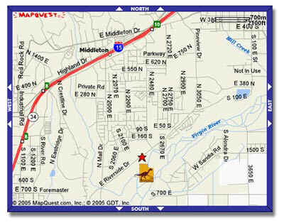
St. George, UT
Triassic and Jurassic Stratigraphy and Nomenclature
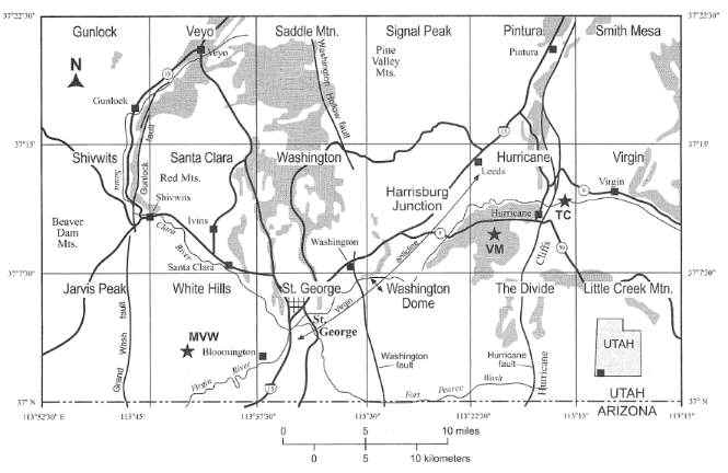
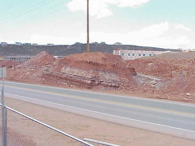
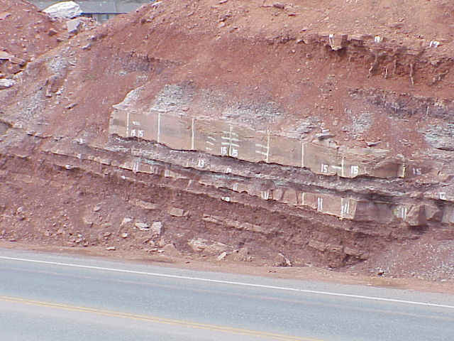
Cross Section from Harrisburg Junction Quadrangle
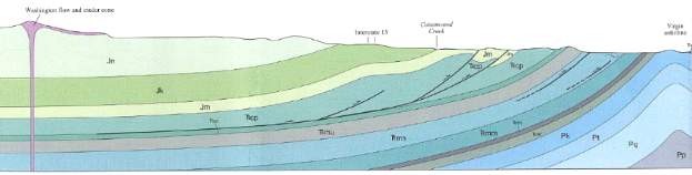
Above figures from Bick, 2003. Geologic map of the Harrisburg Junction quadrangle, Washington County, Utah. Map 191. Utah Geological Survey.
Dinosaur Trackway Discovery
| St. George Dinosaur Discovery Site at Johnson Farm
(Information taken from May 10, 2005, City of St George publication) http://www.sgcity.org/dinotrax/indexmain.php “This is the most significant dinosaur tracksite in western North America.” Dr. James Kirkland, Utah State Paleontologist In late February 2000, Sheldon Johnson was leveling a hill on his farm property in St. George, Utah when he came across dinosaur tracks preserved as natural fossil casts on the underside of a thick layer of sandstone. That sandstone layer was part of a lake shore that dates back approximately 200 million years ago and 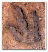 formed when an ancient lake covered the land
just north and east of St. George Utah. When a large block tipped out of the bucket of Dr.
Johnson’s track hoe, he had no idea that he had just uncovered the first trace of an
incredible fossil treasure trove –one of the most important discoveries in the
history of paleontological research in Lower Jurassic rocks. formed when an ancient lake covered the land
just north and east of St. George Utah. When a large block tipped out of the bucket of Dr.
Johnson’s track hoe, he had no idea that he had just uncovered the first trace of an
incredible fossil treasure trove –one of the most important discoveries in the
history of paleontological research in Lower Jurassic rocks. After several years of research and continual discovery, the St. George Dinosaur Discovery Site at Johnson Farm has evolved into a world-class dinosaur site that includes the rare combination of fossilized bones and footprints of dinosaurs and many other ancient animals. When you visit, you will:
“The [St. George] collection is going to be the most important in the world for the researchers working on early Jurassic footprints.” Gerard Gierlinski, Polish Geological Institute, Warsaw, Poland |
WHY ARE THE DINOSAUR DISCOVERIES IN
ST. GEORGE, UTAH SO IMPORTANT?The St. George Dinosaur Discovery Site at Johnson Farm has been described by many paleontologists who have worked at the site as “One of the ten best dinosaur tracksites in the world!” Why does this Site receive such acclaim? An examination of the significant finds and features of the Site tell the story. The Site is one of the most important discoveries in Early Jurassic paleontology history. The St. George Dinosaur Discovery Site provides:
A “SNAPSHOT” OF AN EARLY JURASSIC ECOSYSTEM
The St. George Dinosaur Discovery Site at Johnson Farm (SGDS) represents a “snapshot” of an Early Jurassic (~195 million year old) lake ecosystem at a time when the supercontinent called Pangaea was in its initial phase of break-up and dinosaurs were beginning their ascendancy to becoming the predominant land vertebrates of the Mesozoic Era.
A RARE CONCENTRATION OF TRACE FOSSILS
The SGDS is a rare geological instance of detailed preservation (paleontologically, a lagerstätte) of an Early Jurassic biota (fauna, flora, bacteria, and array of other organisms), preserving an unusual concentration of detailed trace fossils (ichnites) made by:
“pond scum” (bacterial mats, or biofilms); plants; invertebrates, including:
snails (gastropods);crustaceans (arthropods); vertebrates, including
fish;
crocodylian ancestors (crocodylomorphs); and
theropod, sauropod, and possibly ornithopod dinosaurs.
AN ASSOCIATION OF TRACE FOSSILS WITH BODY FOSSILS
The SGDS is also unusual in having body fossils preserved in close proximity to the trace fossils. Organisms represented by body fossils include:
plants;
invertebrates, including
conchostracan arthropods; and
ostracod arthropods;
fish (disarticulated, associated, and articulated specimens);
theropod dinosaurs (teeth, vertebrae); and
possibly other reptiles.
A RARE QUALITY OF PRESERVATION
In addition to the above, the SGDS lagerstätte is unusual because of the quality of preservation, including skin impressions and other fine details of reptilian foot morphology (especially dinosaurs).
A LARGE NUMBER OF TRACKS AND TRACK-BEARING HORIZONS
The SGDS lagerstätte is furthermore unusual because of the number of tracks and track-bearing horizons. Thousands of tracks have been discovered in twenty different horizons.
A LOOK AT ANCIENT ENVIRONMENTS
The SGDS lagerstätte is furthermore unusual because it includes tracks made in different ancient environments, including
lake margin; and
offshore.
AN EXAMINATION OF THE DIVERSITY OF LOCOMOTORY AND OTHER BEHAVIORS
The SGDS lagerstätte is furthermore unusual because it exemplifies:
a variety of behaviors of the track-making organisms, including:
walking;
running;
sitting; and
swimming;
a variety of organisms interacting in the same environment
THE EARLIEST EVIDENCE OF SAUROPODS IN NORTH AMERICA
The SGDS preserves the earliest known evidence of sauropod dinosaurs in North America: the next-oldest evidence on the continent is of Late Jurassic age (roughly 155 million years old), 40 million years after the SGDS tracks.
A MEANS TO RECONSTRUCT AND UNDERSTAND AN ANCIENT ECOSYSTEM
The presence of body fossils (plants and animals) from and in the vicinity of the SGDS, in tandem and correlative with the trace fossils, allows for unprecedented accuracy and detail in reconstructing and understanding Early Jurassic biota.
A RARE EXAMINATION THE FOSSILIZATION OF FOOTPRINTS
The presence of structures created by bacterial biofilms allows a rare examination and testing of the relationship between such biofilms and the preservation of trace fossils.
THE MOST EXTENSIVE SWIM TRACK COLLECTION
The SGDS has the most extensive and best preserved theropod dinosaur swim track collection in the world.
AN INTRODUCTION TO GEOLOGY
Because of the geological setting of the SGDS, it provides an opportunity to introduce patrons to, and educate patrons about, the diverse geology of the St. George area.
A VALUABLE EXAMPLE OF CIVIC RESPONSIBILITY AND PALEONTOLOGICAL ETHICS
The SGDS is unusual in the context of modern paleontology because following its discovery by a local resident on the private property of his small farm; the site was preserved and developed for public and scientific benefit rather than sold piecemeal for profit or wholly ignored. The alternative would have destroyed its value to both the scientific community and the St. George area. This contrasts with the actions of many people regarding recent paleontological discoveries and conveys an important message to site patrons about how to deal with any paleontological resources they may encounter.
Information from ST. GEORGE AREA CHAMBER OF COMMERCE, 97 E ST GEORGE BLVD, ST GEORGE, UT 84770
http://www.stgeorgechamber.com/dinosaur_museum.htm City Paleontologist: Andrew Milner.
Picture Gallery of Tracks, Plants, and
Stratigraphy
photographs by Bruce Cornet (April 2004)
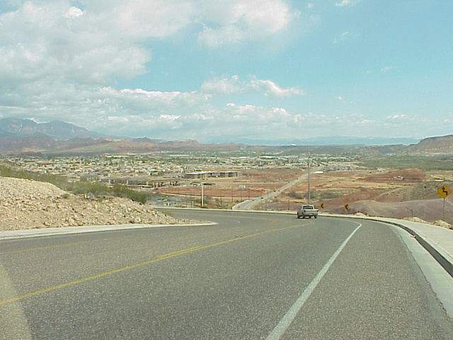
View of dinosaur track site from Middleton Black Ridge (Tertiary basalt), looking north. White tent is visible above truck on road, to right of road (E. Riverside Drive).
Temporary Specimen Shelter
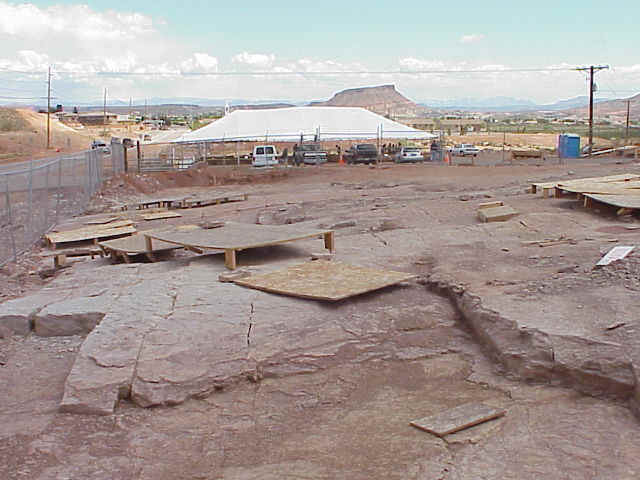
Temporary Exhibition Tent
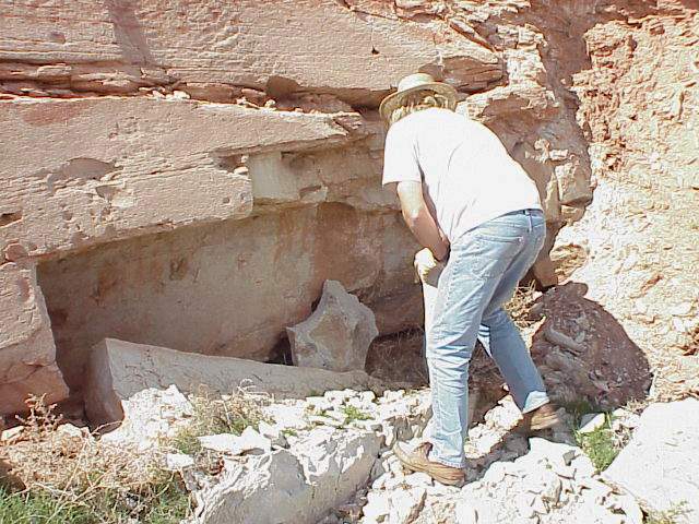
Andrew Milner, City Paleontologist
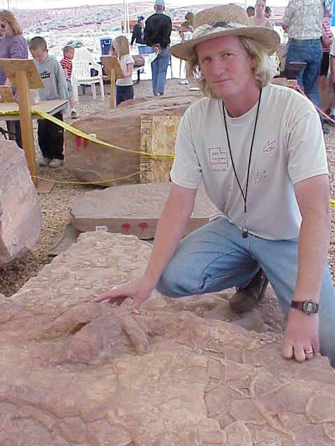
Milner at sauropod track site
Above: The earliest record of sauropods in North America.
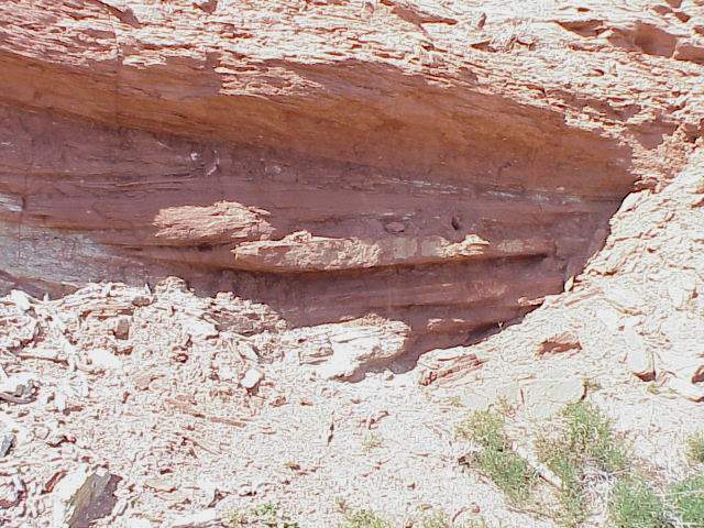
Local Whitmore Point Member Stratigraphy
Above: Outcrops of the Whitmore Point fluvio-lacustrine beds on opposite side of E. Riverside Drive. Middleton Black Ridge in the background. The Fossil Hill Elementary School can be seen behind the outcrops.
Above: Fluvial-deltaic sandstones interbedded with shallow lacustrine mudstones.
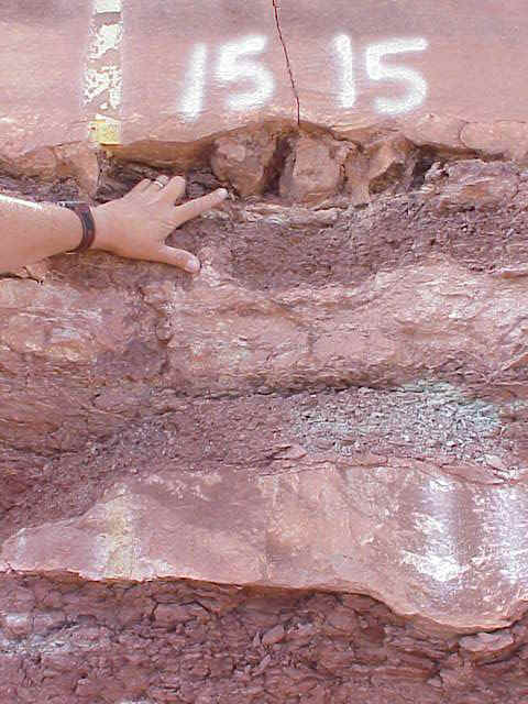
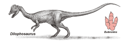
Above: Cross section of a Eubrontes footprint (hand pointing), showing that the fine sandstone on top was deposited rapidly soon after dinosaurs had walked on the underlying mudstone, leaving deep footprints while the mudstone was still soft.
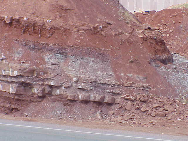
Above: Grey and purple shale and mudstone beds, represent shallow lake deposits; the thickly-bedded sandstones represent fluvial sandstones deposited during floods or as prograding deltaic lobes at the edge of a lake.
Above: Fluvial overbank mudstone with burrows, mudcracks, and root casts, deposits above a lake bed (purple).
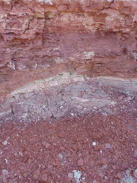
Above: Possible volcanic ash layer (pinkish white), indicating volcanic activity in the Cordilleran Mobile Belt (West Coast) as rifting intensified along the East Coast, and as a proto-Atlantic Ocean appeared between the North American and African plates during the breakup of Pangaea.
Whitmore Point Sedimentary Structures
Above: Current ripples indicating flowing water after mudcracks and footprints were formed.
Above: Hopper casts (pseudomorphs after evaporite minerals), indicating that the lake water was brackish to slightly alkaline.
Above: Hopper (= "salt") casts from a lower Portland Fm. lacustrine bed in the Hartford basin, Connecticut and Massachusetts (shown for comparison). Crystal shape indicates that they were probably gypsum crystals that formed within the sediments during deposition. Surface weathering has removed the gypsum, leaving their casts behind.
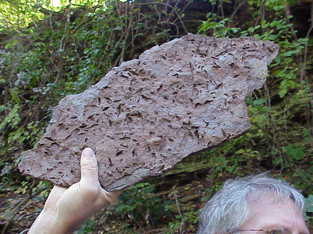
Excavated Fossils
Above: Inventory at the specimen shelter.
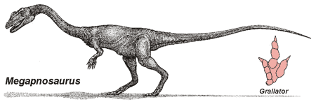
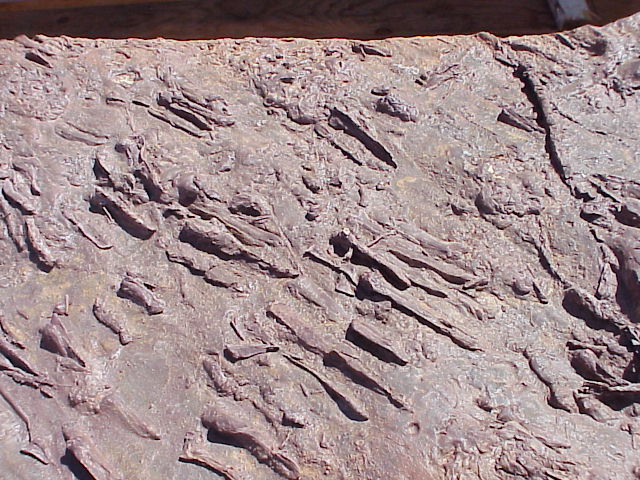
Above images: Eubrontes and Grallator footprints stored in the temporary specimen shelter. You are looking at the underside of the overlying massive fine sandstone unit that covered the tracks, producing casts of the positive prints on the underlying mudstone.
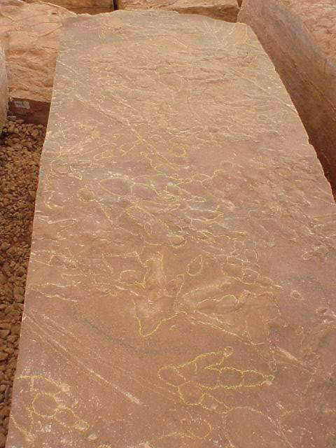
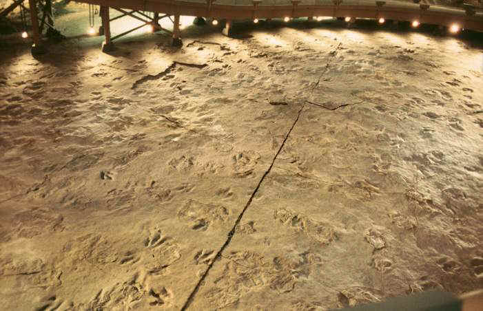
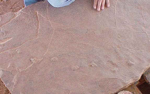
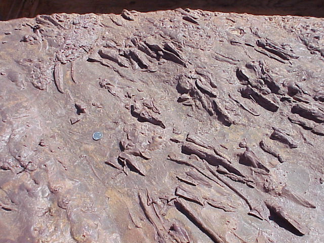
Above: Slab on exhibit under the tent, showing numerous Grallator and Anchisauripus tracks crisscrossing an exposed lake margin.
Above: Grallator track showing foot pads and claws.
Above two images: Eubrontes footprint on exhibit under the tent from different angles. You are looking at the underside of the overlying massive fine sandstone unit that covered the tracks, producing casts of the positive prints on the underlying mudstone.
Above: Radial mudcracks around a Eubrontes track indicate that the footprint came first.
Above three images: Mudcracks deformed by a Eubrontes track indicate that the footprint was made after the mudcracks formed. You are looking at the underside of the overlying massive fine sandstone unit that covered the tracks, producing casts of the positive prints on the underlying mudstone.
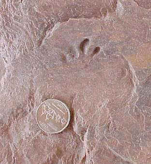
Above: Trackway of a small unknown reptile.
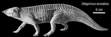
Above: Batrachopus-like track, which is thought to have been produced by Stegomus, a crocodilian ancestor.
Above: Possible mammal footprints.
AD: We offer best quality C4120-782
braindumps test papers and 642-999
materials. You can get our 100% guaranteed ccie data center lab
questions & 300-206 braindumps
to help you in passing the real exam of server+ training.
[11.24.14-17]
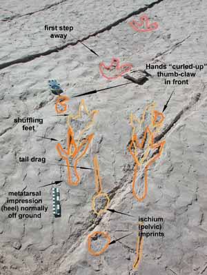
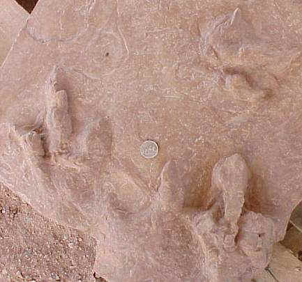
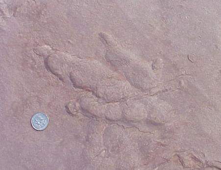
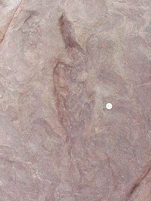
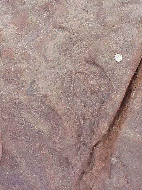
Squatting Dinosaur Tracks at Johnson’s Farm
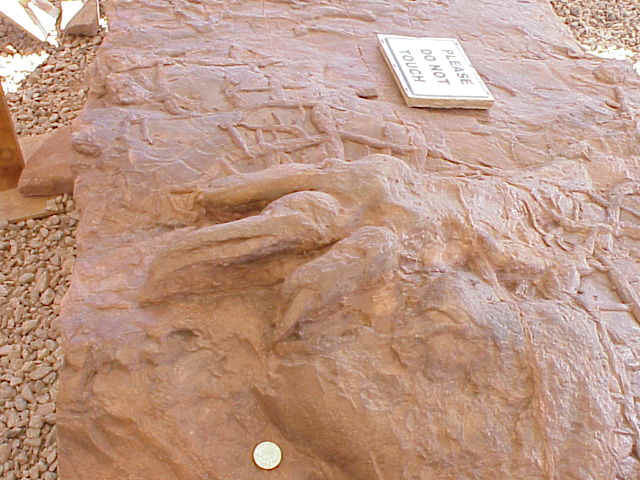
Above: Reconstruction of trackmaker and foot of the squatting dinosaur. Courtesy, James I. Kirkland.
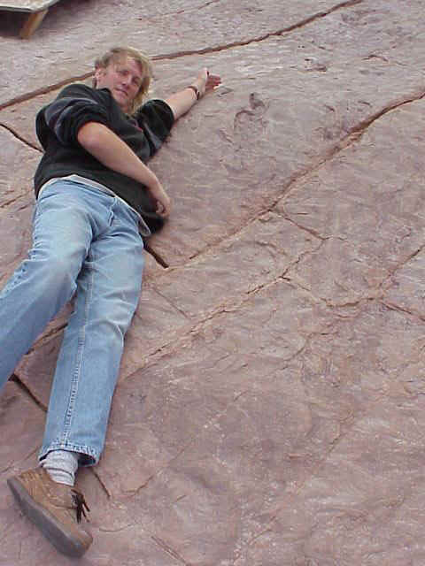
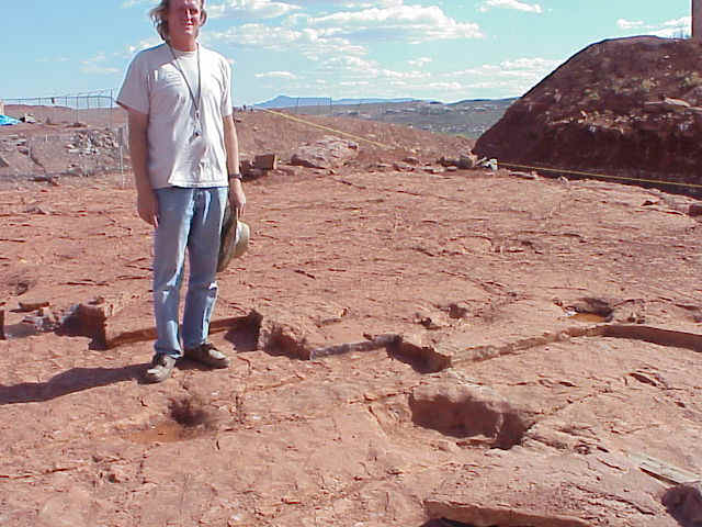
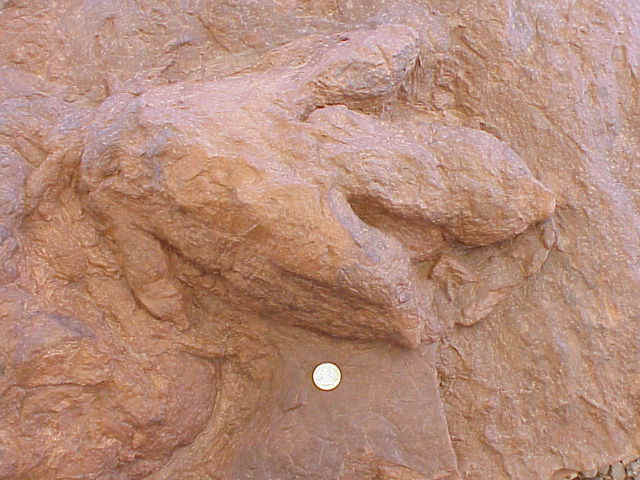
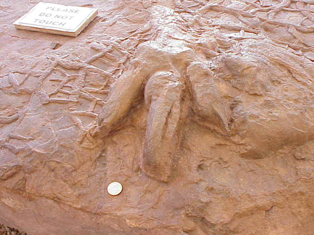
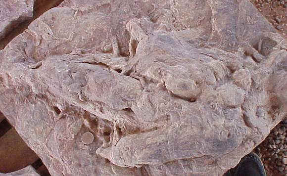
Above: Andrew Milner lying next to the body impression of a squatting dinosaur. Most distant tail impression is just below his shoe (see close-up below). Milner can barely stretch the distance from the tip of the dinosaur's tail to where its front feet made an impression. The head and neck of the dinosaur would have extended even further above Milner's hand.
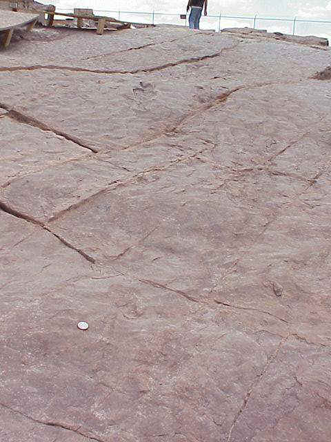
Above: Zoom out picture showing trackway with body impression where dinosaur stopped and squatted. A tail impression is located just to the right of the quarter used for scale.
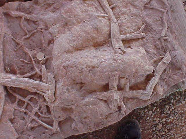
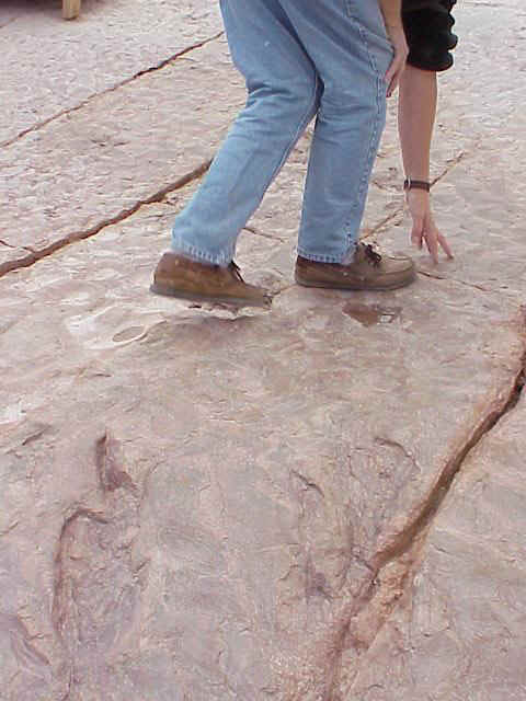
Above: Body impression labeled, courtesy Utah Geological Survey and Nancy Carruthers. Details and close-ups below.
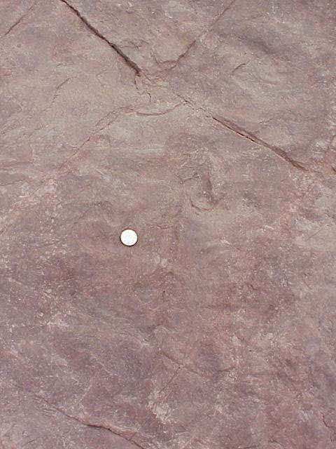
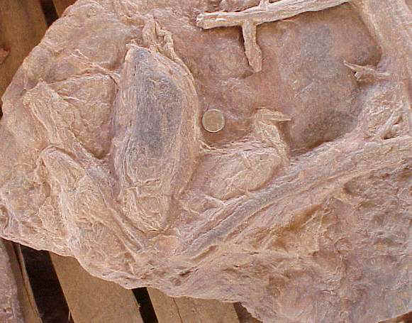
Above: Close-up of tail impression to the right of the quarter.
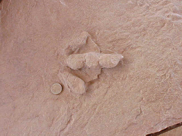
Above: Close-up of metatarsal impressions (heel), usually off the ground.
Above: Left hind leg showing metatarsal impression (heel).
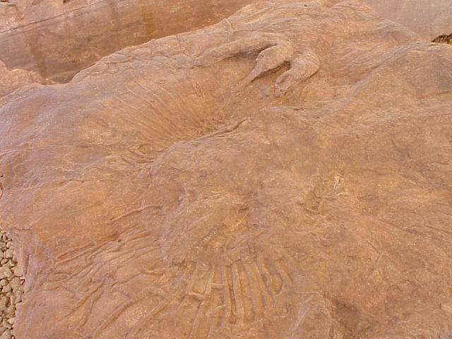
Above: Right front limb impression showing curved claws.
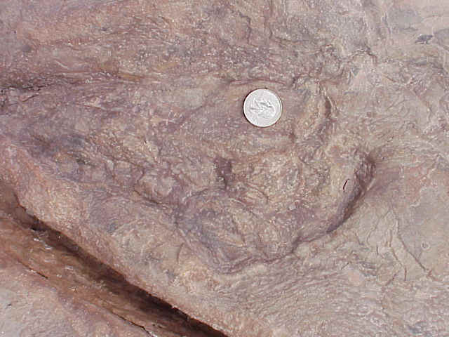
Above: Close-up of right hand with claws.
Swimming Dinosaurs
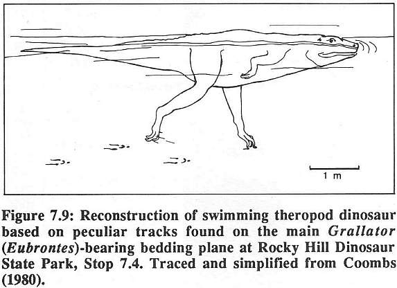
Above figure 7.9 from Schlische, R.W. and Olsen, P.E., 1989. Geology of the Hartford and Deerfield Basins. In Olsen, P.E. and Gore, P.J.W. (eds.), Tectonic, Depositional, and Paleoecological History of Early Mesozoic Rift Basins, Eastern North America. 28th International Geological Congress, Field Trip Guidebook T351: 107-118.
Above: Claw gouge marks made by swimming dinosaurs as water depth became too high for them to walk on the lake bottom. You are looking at the underside of the overlying massive fine sandstone unit that covered the tracks, producing casts of the positive prints on the underlying mudstone.
Above: Dozens of parallel claw marks might indicate that these dinosaurs swam together in migrating herds, crossing shallow narrows in the lake. You are looking at the underside of the overlying massive fine sandstone unit that covered the tracks, producing casts of the positive prints on the underlying mudstone.
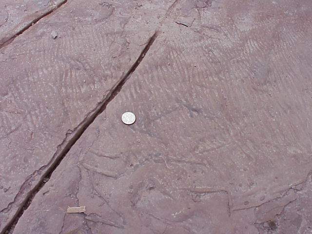
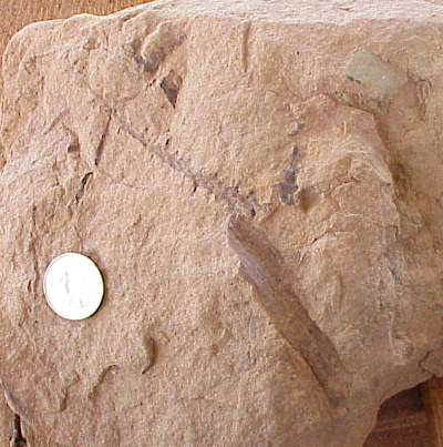
Invertebrate Trackway from the Whitmore Point Member
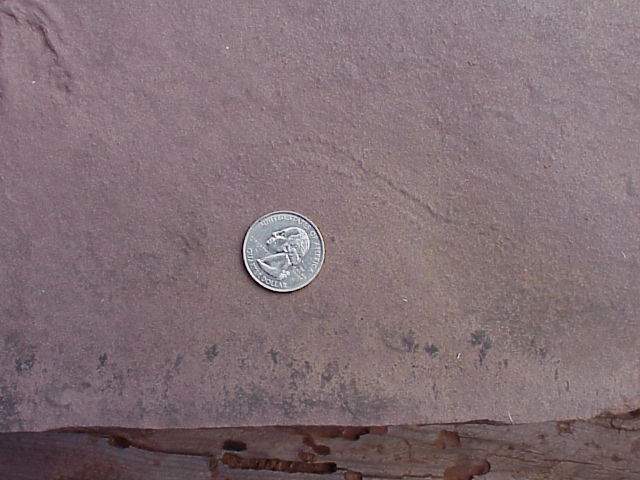
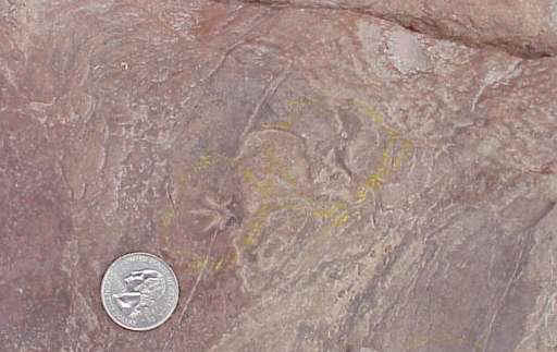
Above: Invertebrate trackway (crayfish or insect) from a dinosaur footprint layer (just above quarter).
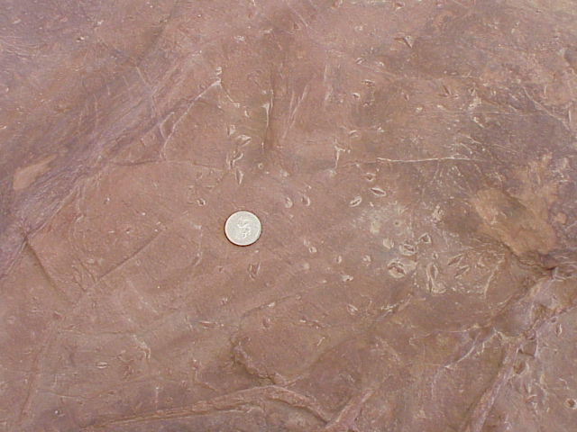
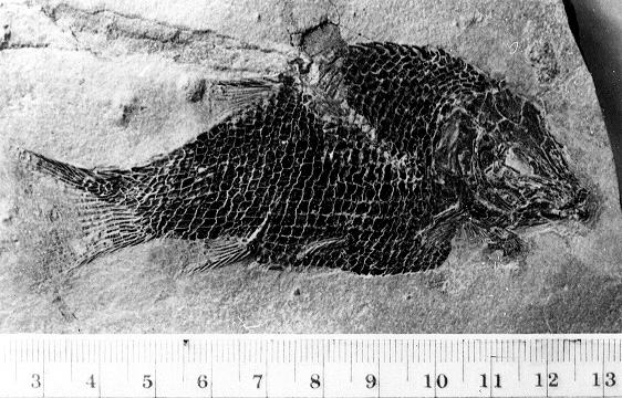
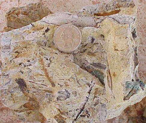
Semionotus, a Fossil Fish from the Whitmore Point Member
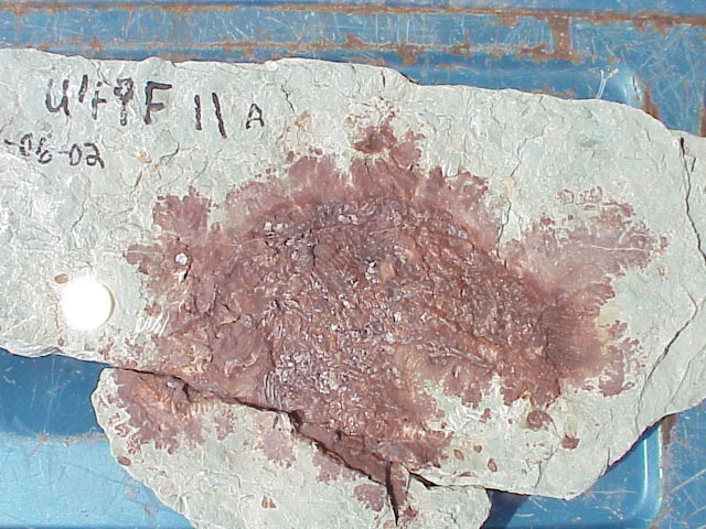
Above: Semionotus kanabensis, a holostean fish from one of the deeper lake units in the Whitmore Point Member.
Above: Semionotus sp. (for comparison) from the basal Jurassic Bluff Head locality, Shuttle Meadow Formation of the Hartford basin, Connecticut. For more information, go to http://www.monmouth.com/~bcornet/blufhead.htm. This specimen was prepared by B. Cornet.
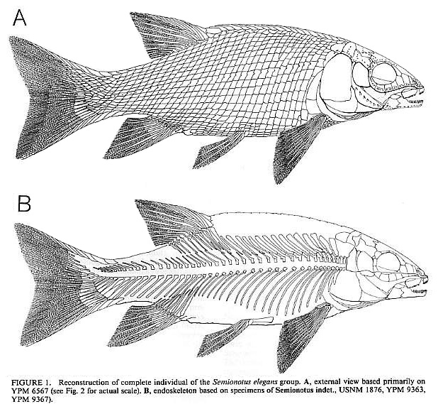
Above drawings by P.E. Olsen.
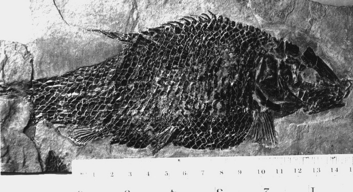
Above: Semionotus elegans (for comparison) from the basal Jurassic Bluff Head locality, Shuttle Meadow Formation of the Hartford basin, Connecticut. For more information, go to http://www.monmouth.com/~bcornet/blufhead.htm. This specimen was found and prepared by B. Cornet.
Fossil Plants from the Whitmore Point Member
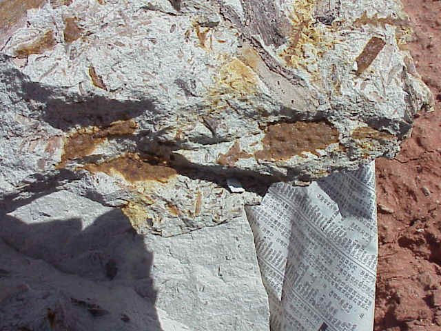
Above: Cliff exposure of Moenave Formation directly beneath plateau where dinosaur track beds are located. Channel sandstones containing plant fossils are located at the top of this exposure (in foreground). The buff-colored sandstone unit thickens behind the photographer, where a point bar sequence is exposed.
Above: Channel sandstones (point bar) displaying cross bedding. Sandstone beds thicken (become more massive) to the right of this photograph, where plant fossils were found.
Andrew Milern lifting slabs of channel sandstone containing stems, leaves, and cones of conifers.
Above: Conifer branch with leaves (Brachyphyllum sp.) found in a light brown siltstone-fine sandstone.
Above: Conifer twigs and plant debris from a point bar sandstone.
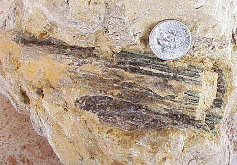
Above: Stem or branch of a plant with a wide pith and a thin outer ring of wood (black).
Above: Conifer branch bearing Pagiophyllum leaves.
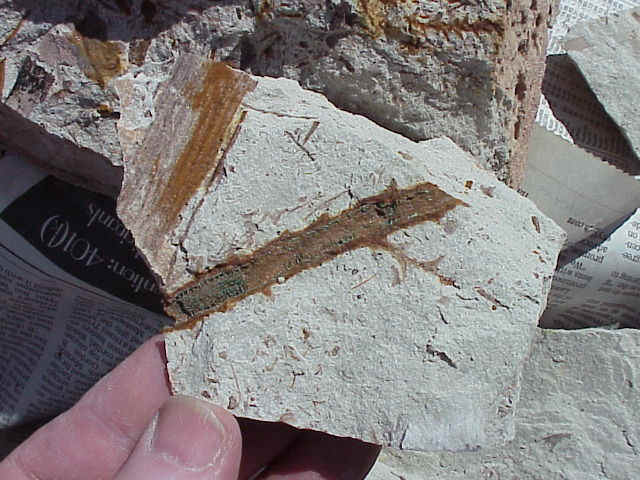
Above: Cones associated with the Pagiophyllum leaves and branches.
Above: Plant debris deposited in a point-bar fine sandstone, illustrating Pagiophyllum branches/leaves, tree bark, twigs, and wood.
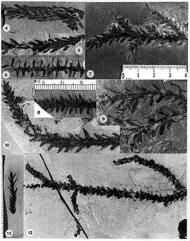
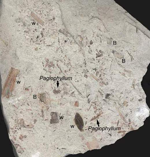
Above: Various types of conifer foliage from the Early Jurassic of North America. Two types of form-genera are illustrated: Brachyphyllum sp. (12); Pagiophyllum spp. (4-11). Pagiophyllum in figure 9 was found attached to cones of the Cheirolepidaceae. The microphyllous Brachyphyllum sp. 12 comes from the oldest (Feltville Fm.) Jurassic strata in the Newark basin, PA-NJ-NY, while the macrophyllous Pagiophyllum sp. 9 with the longest leaves comes from the youngest (Portland Fm.) fossiliferous strata in the Hartford basin, CT-MA, indicating a decrease in aridity and/or temperature through the Hettangian and Sinemurian on the East Coast following a mass extinction at the Triassic-Jurassic boundary. The Whitmore Point Mbr. conifer leaves fall in between these two extremes. Pagiophyllum sp. 4 resembles foliage of the extant Monkey Puzzle Tree from Australia (Araucariaceae). For more information on Early Jurassic conifers, go to http://bcornet.homestead.com/files/Conanthus/conanthus.htm.
A Basal Jurassic Water Lily?
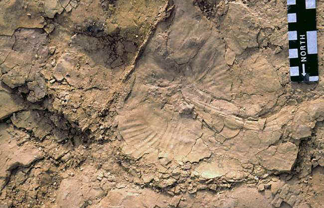
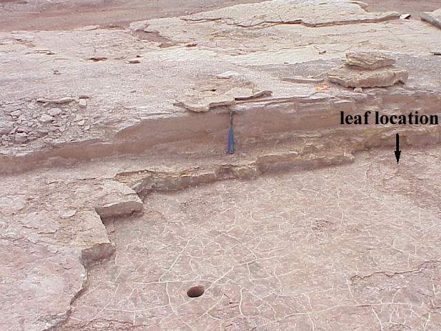
Above: Location where the dinosaur trackway was found with one footprint containing the leaf fossil. Exfoliation from rain severely damaged the footprints and leaf fossil before they could be coated with preservative.
The leaf impression was found inside a dinosaur track impression. The fossil was photographed and casts made of it before it was destroyed. The picture below appeared in the Utah Geological Survey publication, Survey Notes (Kirkland, et al., 2002).
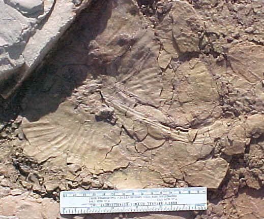
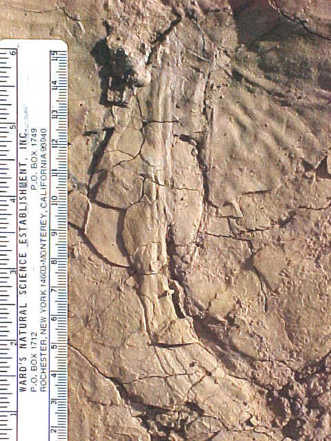
The leaf is 26 cm wide, with a petiole at least 18 cm long.
Above images and close-ups courtesy of James I. Kirkland, Utah Geological Survey.
This leaf impression resembles an extant Nuphar leaf (Nymphaeaceae), complete with petiole and impressions of radiating veins.
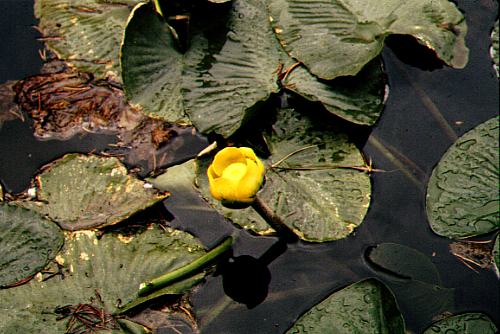
Above: Nuphar polysepala from Wyoming. Photo by Barre Hellquist.
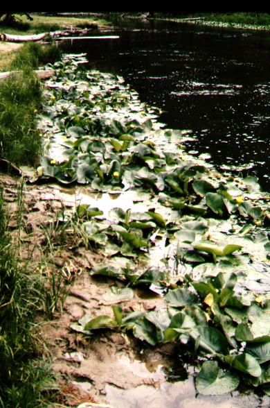
Above: Nuphar polysepala from Wyoming. Photo by Barre Hellquist. Note footprint impressions in soft mud and how a lowering of lake level exposes the footprints and plants to drying and potential fossilization, if additional mud is deposited on top of the dried leaves and prints in a subsequent flood or rapid rise in lake level during a heavy rain.
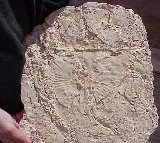
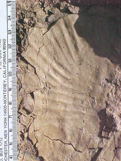
Above: A cast was made of the specimen before it was destroyed by rain. The outline of the dinosaur track is shown; it was within this track that the leaf impression was preserved. The leaf was either 1) washed into the track after it was made, or 2) it was sticking to the bottom of the dinosaur's foot until this step, where the leaf came off the foot and stayed with the imprint. The second explanation would explain the damage to the leaf lamina and squashed (splayed) appearance of the petiole (more flattened under the "heal"). It would also mean that the dinosaur trekked through a patch of these water plants before coming out of the water onto the muddy bank of Lake Dixie.
The dinosaur trackway shows the direction from which the theropod traveled
before the leaf fell off the bottom of its foot. The leaf was squashed and distorted
(petiole splayed out) enough to indicate that it had traveled with the dinosaur for a good
number of steps (stuck on by mud and/or between the dinosaur's toes). The relatively
good condition of the fossil impression after having been stepped on however many times
between the lily patch and where the detached leaf ended up speaks volumes on its
durability (ruggedness and laminar thickness). Nuphar leaves are equally
durable (thick), making it an excellent example for comparison.
Retracing the path of the theropod places it across E. Riverside Dr. in a quarried
area where dinosaur bones have been found, a sauropod trackway, many theropod tracks,
and what Andrew Milner pointed out as possible plant root casts. Those
"roots" resemble thick rhizomes (horizontal in situ stems) spreading
through the lakebed siltstone and mudstone layers. If they represent a colony of
water lilies, by excavating that layer, additional leaves (attached) and even reproductive
structures and seed pods might be found.
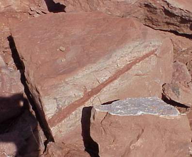
Above: A block of siltstone and overlying darker mudstone contains a cast of a rhizome (horizontal stem) bearing dozens of small rootlets. This specimen came from the rock layers below the sauropod trackway. The light gray aureole around the rhizome was caused by the reducing effect of decay, while the red cast represents infilled red clay after the rhizome decayed. At least one upwards branch might represent the base of a leaf petiole (the rest of the leaf may be hidden in this block or in its counterpart). Only through additional excavation and preparation of specimens such as this will it be determined if more of this plant is preserved in that unit.
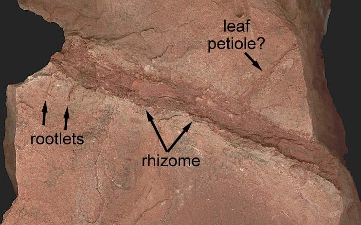
Above: Close-up of another block of mudstone containing the cast of a rhizome with rootlets, and a possible attached petiole base.
If this fossil belongs to the Nymphaeaceae, it would not only confirm the basal position of the Nymphaeaceae based on molecular evidence, but also extend crown-group angiosperms back at least to the basal Jurassic. Additional specimens, along with reproductive structures are needed to prove the fossil is that of an angiosperm. Nevertheless, it establishes that this plant existed; if it was preserved once, it will probably be preserved elsewhere in these deposits. See why.htm.
This page was first created by Bruce Cornet on 10 May 2005.
This page was last modified on 11/26/2014.
 St.
George Dinosaur Discovery Site at Johnson Farm is a must-see for anyone
interested in dinosaurs, geology and the ancient Jurassic world.
St.
George Dinosaur Discovery Site at Johnson Farm is a must-see for anyone
interested in dinosaurs, geology and the ancient Jurassic world.